![]()
ENG:Glaciar del Morado


|
|
|
| |||||||||||||||||||||||||||||||||||||||||||||||||||||||||||||||


 ATTENTION: Do not confuse this route with the trek Glaciar San Francisco y la Laguna de Morales (sometimes mistakenly called El Morado Lagoon), located in El Morado National Monument ATTENTION: Do not confuse this route with the trek Glaciar San Francisco y la Laguna de Morales (sometimes mistakenly called El Morado Lagoon), located in El Morado National Monument
|
When to visit

- Trekking:From October to May. During October and November there could be a considerable amount of snow to hinder the hike and make it impossible to reach the end of the road by car, but this will be rewarded with an even more beautiful landscape than in the summer months.
- Ski Touring: Between June and mid-October. Keep in mind that starting mid-August it might be necessary to carry your skis on first stretch. On the other hand, in mid-winter the car path is cut at Lo Valdés mining facilities, so you might have to start at Baños Morales.
Access
From the intersection at las Vizcachas (Avenida Camilo Enríquez and Avenida Eyzaguirre, km 0), take the road G-25 towards Cajón del Maipo, and follow it until km 65.1 (asphalt ends in the km 66.3 just before Lo Valdés) where there is a bifurcation. To the left, it leads to Baños Morales along a dirt road, located on the other side of the El Volcán river. Between June and September this road might be closed if there have been recent snowstorms. You can check the road status with Carabineros at San Gabriel (+56228611008 y +56228612290) although their answers tend to be on the conservative side.


After 1,6 kilometers from the fork at Baños Morales, the paved road ends and you will pass Lo Valdés mining facilities, where there is some accumulation from the gypsum mine. Six kilometers further from the fork to Banos Morales, and after the "Cuesta de los Afligidos" hill, you will reach a bridge that crosses the Colina river. Just 120 meters after this bridge you will reach "Cabrerío" (see photo), to the left of the main path.
"Cabrerío" consists of basically a shelter that is frequented by herders. You can recognize it by a large rock with a small chimney on the top. Here is where the main road is abandoned by turning left on the fork in front of "Cabrerío" to venture into the Arenas mountain valley (set the kilometer marker to zero at this point).
This new dirt road (marked blue on the map) is kept by Alto Maipo hydroelectric power station, and is in excellent condition and good for any vehicle.
The power station has closed the old road on their work area, but has opened a new one that goes further up. On kilometer 6,5 it joins with the old road and reaches a nice plateau, popularly known as "El Choriboulder" due to the large amount of climbing boulders in the area, and a bouldering event that took place here in 2004.
When the road begins to separate from the valley and ascend on the hillside (kilometer 8,05 from Cabrerio), find a wide space to park and begin the hike.
If you drive a 4x4 you can continue for two more kilometers on the old road in very bad condition. The drive here is almost at walking pace, so the usefulness of this road is debatable.
Access by Public Transportation and Autostop
Public busses to Cajón del Maipo
- Public busses (subsidized): El Alfalfal – San José de Maipo; Baños Morales (Lo Valdés) – El Volcán – San José de Maipo and El Volcán–San José de Maipo cost CLP$1200 (US$ 1.2 as of April 2024). It can cost as little as $300 for shorter distances.
- Turmaipo: From October to January first, Saturdays, Sundays and holidays. Daily in January and February. Departures at 7:30 AM and from Baños Morales at 18:000. It departures from Terminal de Metrobuses Bellavista de la Florida, platform E, or from Las Mercedes (Puente Alto) around 7:50. In San José de Maipo at about 8:35, to finally reach Baños Morales around 10:15. CLP$8000 (US$ 8.1 as of April 2024) round trip to Baños Morales, cheaper for shorter distances. Phone: +56228424208, +56222830082, +56228611518, cell +56982896718
- Buses TurMarzur: Phone +56993357800
Private vans to Cajón del Maipo
- Turismontaña: +56991219203
- Baños Morales: CLP$10000 (US$ 10.2 as of April 2024) round trip, per person, $12000 if you return a different day.
- Embalse El Yeso: CLP$10000 (US$ 10.2 as of April 2024) per person
- Turismo Arpue: CLP$10000 (US$ 10.2 as of April 2024) per person. Bookings at least 24 hours in advnace +56222117165 - +56226818475 cel: +56999320108
Both companies depart from Baquedano Metro Station (red and green lines), at the side of Telefónica building. The departure is at 7:30, to reach Baños Morales at about 10:00.
If you take the bus to Banos Morales, there are good chances to make the autostop up to Cabrerio. Getting an autostop from Cabrerio to the parking space (red route) is harder but possible, especially during the summer weekends. If you decide to take the bus and you don't want to try autostop, walk the yellow route.
Route Description

Having parked the car, abandon the main route to take a car path in bad condition, that will become progressively in very bad condition. On the first two kilometers, the path will go by the back of the valley on the west side of the river, where it will slowly gain altitude. At 2.805 AMSL you will pass next to a flag.
Afterwards, the path will begin to distance itself from the main river of the valley, each time higher on the mountain hillside. The slope becomes considerably steeper than on the first stretch of the trek. You will have to continuously cross small creeks on the path. The route is always visible since most of it takes place on the old car path.
You will then have to cross a creek (3.039 AMSL) that comes from the northeast and ascend it on its east side (right side). This is the steepest stretch.
After having crossed the small creek, at 3,079 AMSL, you will reach the absolute end of the car path (Sidenote: In March of 2013 it was still possible to reach this point by car). Reaching this point by car is very difficult and risky: on the highest stretch this old car path is nothing more than a print with big loose rocks). (ver foto del lugar hasta donde se puede llegar en vehículo 4x4)
Although the start of the walking path is noticeable, this area is covered in snow during the beginning of the summer. ver imagen The lagoon is located in a cirque that forms to the west of this valley, so you must walk in that direction.
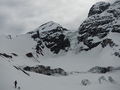
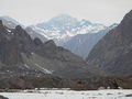
You will then reach a flatter area, always on the right side of the creek, which you will here cross for a second time at 3.150 AMSL and then go up the last moraine, where the incline gets steeper. The path does not face the slope directly to the west, but in an oblique line to the northeast. Right at the end of the ascent you will be rewarded by a spectacular panoramic view of El Morado hanging glaciar Cerro Morado, its adjacent glaciers, and its lagoon with ice floes.
Return on the same route
Baños Morales Stretch - Main Route Junction (for ski touring or public transportation)

If upon reaching Lo Valdés gypsum mine the path is closed (which is likely to be the case between June and September) you will have to return and take the detour to Baños Morales, and advance on Volcán's river's north side. It is 5.6 kilometres along the yellow route, on an old car path - good for skying - up to the junction with the path that starts at Cabrerio, ascending from 1860 AMSL to 2275 AMSL. This should take a little less than two hours. From this junction, it's 5.4 kilometers more along the blue route to the beginning described on the previous section, and that can be reached by car when there's no snow. This stretch entails an ascent from 2275 meters to 2628 meters, which should take another 1.5 hour or so.
Estimated Duration
At a normal pace and finishing the route, the hike should consist of 3 hours going up and 2,5 hours back down. Add an extra hour if you are starting from "choriboulders" area.
Permits / Fees

- From 2015, you need a permit to take a car through the valley. It can be requested by writing to vallelasarenas@gmail.com and informing the participants' names and license plate. This permit is free.
- Phone numbers: +56229852609, +56997829336
- Entry is until 4:00pm and exit until 8:00pm.
- These lands belong to Parque Natural Privado Valle Las Arenas
Hiring Guides
Hiring guides is possible for this trek:

- Contact: guia@montananativa.com
- Phone: +569 6477 8461
- Social Media: Facebook Montaña Nativa
- Ecotrekking Santiago de Chile Ecotourism and "High Mountain" activities in Cajón del Maipo and Farellones. Logistics, guides, and passenger transport.

- Contact: ecotrekkingchile@gmail.com
- Facebook: Ecotrekking Santiago de Chile
- TripAdvisor: Ecotrekking Chile
- Phone: +56966028918 (WhatsApp)
- Ecochile Travel: Regular and private trekking trips in the Andes.
- Contact: info@ecochile.travel, (56- 02) 25708826


- Flecha Extrema: Private Hiking Tours / "High Mountain" Expeditions around Santiago - Experience the Andes
- Contact: contacto@flechaextrema.com, +56 9 65 61 72 77
- Facebook Turismo Flecha Extrema
- Phone: +56965617277 (Whatsapp)
- AndesBrown: Hikes and excursions in Chile's central mountains. Guided tours, certified guides
- Phone +56988382014.
- Cajonoutdoor: Treking, horse back, and excursions in all of Cajón del Maipo. Passenger transport to and from the hotel/airport/chosen destiny. Bilingual local guides.
- Contact: contacto@cajonoutdoor.cl
- Phone: +56991940429 - +56975275503.
Hiring horses and/or mules
Roberto Molina and Katerina Cáceres offer horses and mules, departing from Baños Morales: +56287100051, +56991667566. Consider about CLP$15000 (US$ 15.3 as of April 2024) per day per horse.
Weather Report
Photo Gallery
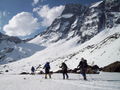
Ski touring in El Morado Glacier during the winter
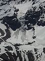
Glaciar del Morado as seen from the route of ascent to Cerro Arenas. The lagoon appears frozen on the base of the glacier, but notice the ice melting on the banks. November 2012
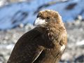
Mountain "Carancho" in El Morado Glacier (juvenile specimen)
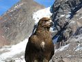
Mountain "Carancho" in El Morado Glacier (juvenile specimen)

.JPG)


Choriboulder a principios de octubre
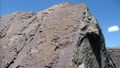
Grietas de secamiento naturales en el sector de choriboulder. Imagen: Alejandro Gallardo E
Zona de los choriboulders en septiembre de 2004
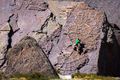
Escalando el choriboulder en 2004. Fotografía: Pablo Azócar


Area Description
This information was obtained directly from Parque Natural Privado Valle Las Arenas and translated
Geography
This area presents two types of climate: A temperate one with a long dry season and an ice one due to the effects of the altitude. The average annual temperature is 13ºC, and the annual average rainfall reaches 600mm. Humidity is over 40% for most of the year. The Arenas Valley belongs to what is called "Cuenca Superior Río Volcán" (High Basin of the Volcan River), making it one of the main tributaries of the Volcan river, along with the sub-basin of La Engorda river. The highest flowrates occur during the months of November and March, due to the rising temperatures. During the winter months, the flowrate is markedly decreased.
Geomorphologically speaking, high mountain morphogenetics take place here, where erosive processes dominate and work to transport material and wear away the hillsides.
Flora and fauna

Regarding the flora, low shrubs no higher than 50cm dominate the area, alternating with turfs of gramineas, with hard leaves. Perennial herbs dominate humid sectors. Native species stand out along with wild exotics. You can find the sclerophyllic Andean scrub, and the high Andean steep of the Santiago mountain range forms in the high Andean sector (Volcan river) There is a total of two threatened species in the Vocan river area: Laretia acaulis and Alstroemeria exerens.
A total of 86 species can be found here: three amphibians, nine reptiles, 70 species of birds of which nine are hunters, 10 aquatic birds and 51 not predatory, and four are mammals. In El Morado river area, there are about 16 species in conservation status, most of which are reptiles, followed by amphibians, mammals and birds.
During the end of 2007, geologist Christian Salazar and professor Dr. Wolfgang Stinnesbeck (geologist and paleontologist), both from Heidelberg University in Germany, discovered fossils that dated back to 150-155 million years ago.