![]()
Diferencia entre revisiones de «ENG:Neozelandes Camp, RN Cerro Castillo»
| (No se muestra una edición intermedia del mismo usuario) | |||
| Línea 26: | Línea 26: | ||
|TipoDeMap=HYBRID | |TipoDeMap=HYBRID | ||
}} | }} | ||
| − | [[Archivo:Perfil_altitud.png|thumb| | + | [[Archivo:Perfil_altitud.png|thumb|Altitude profile of the trail. Notice the great vertical drop of 900 meters. Click para agrandar]][[Archivo:Sendero_Valle_Parada.jpg|thumb|Path up the Estero Valley Stop for the New Zealand Camp. Behind the Cerro Palo and Cerro Chocolate. Foto: Fabian Hellwig]] |
| − | [[Archivo:Sendero_en_Bosque_Valle_Parada.jpg|thumb| | + | [[Archivo:Sendero_en_Bosque_Valle_Parada.jpg|thumb|Path to the interior of Lengas forest after the Porteadores camp. Foto: Fabian Hellwig]] |
| − | [[Archivo:Claro_antes_de_Campamento_Neozelandés.jpg|thumb| | + | [[Archivo:Claro_antes_de_Campamento_Neozelandés.jpg|thumb|Clear in the forest before arriving at the New Zealand Camp. Cerro del Fondo is Punta Duff. Foto: Fabian Hellwig]] |
== General Description == | == General Description == | ||
World famous is Cerro Cerro Castillo, clear star of the eyes of all visitors to the reserve of the same name. However, behind this colossus there is a valley that dazzles with great mountains of rock and fantastic landscapes. It is the valley of the estuary Parada, which, because it is usually at the end of the [[Trekking Cerro Castillo]] is overlooked by most of the walkers. However, this valley deserves the detour or even be the objective of an own excursion to enjoy this fantastic world of mountains. | World famous is Cerro Cerro Castillo, clear star of the eyes of all visitors to the reserve of the same name. However, behind this colossus there is a valley that dazzles with great mountains of rock and fantastic landscapes. It is the valley of the estuary Parada, which, because it is usually at the end of the [[Trekking Cerro Castillo]] is overlooked by most of the walkers. However, this valley deserves the detour or even be the objective of an own excursion to enjoy this fantastic world of mountains. | ||
| Línea 42: | Línea 42: | ||
==Description of the rout == | ==Description of the rout == | ||
| − | + | ||
[[File: Perfil_cerro_castillo.PNG | thumb | center | 750px | Profile of the Cerro Castillo trekking circuit. The red vertical lines separate the days]] | [[File: Perfil_cerro_castillo.PNG | thumb | center | 750px | Profile of the Cerro Castillo trekking circuit. The red vertical lines separate the days]] | ||
| − | + | Cross the fence in the same Estero Parada (km 0, 300 meters above sea level) and continue walking along the animal tracks towards the point where the Estero Parada leaves the box (km 1.5, 440 msn,). Here the path is clearly recognized, which ascends the slope in a zigzag and crosses a fence in the upper part. Continue on the trail that goes into the valley ascending constantly. At kilometer 2.5 (600 masl) entrance to the Cerro Castillo National Reserve is made, with the land to this point being private. About a kilometer ahead there is a viewpoint overlooking Cerro Palo. | |
| − | + | ||
| − | + | ||
| − | + | ||
| − | + | ||
| − | + | ||
| − | + | ||
| − | + | ||
| − | + | ||
| − | + | ||
| − | + | ||
| − | + | ||
| − | + | ||
| − | + | ||
| − | + | ||
| − | + | ||
| − | + | ||
| − | + | ||
| − | + | ||
| − | + | ||
| − | + | ||
| − | + | ||
| − | + | ||
| − | + | ||
| − | + | ||
| − | + | ||
| − | + | ||
| − | + | ||
| − | + | ||
| − | + | ||
| − | + | ||
| − | + | ||
| − | + | ||
| − | + | ||
| − | + | ||
| − | + | ||
| − | + | ||
| − | + | At kilometer 4.1 (860 masl) you reach the junction with the path that comes down from Cerro Castillo Lagoon. The trekkeros that come down from the lagoon should continue along the route described here to go up to the New Zealand camp. Just a few meters further on, a small estuary is crossed and there is the Porteadores Camp, which with a small roof and a table is a good resting place but does not have much space for tents. | |
| − | + | The path ahead definitively enters the forest and continues always ascending slightly through the valley. Some estuaries that descend from the slope of Cerro Castillo cross the path. At kilometer 7.3 (1130 meters above sea level) you will reach a large clearing in the forest where for the first time you can see a panoramic view of the mountains that surround the valley. The gentle north-western slope of Cerro Castillo stands out, topped by capricious rock spiers. The clearing must be traversed by the forest. Just 500 meters further on, you cross an estuary and finally arrive at the New Zealand Camp, a pleasant camping area located within a large forest of Lengas (km 7.9, 1,160 meters above sea level). There are camping sites with some tables and a latrine. | |
| − | + | ||
| − | + | To admire the view of the valley continue a few meters up valley, because the forest gives way to a large meadow next to the Estero Parada in which you have a complete view of the entire amphitheater of hills around. It is also possible to continue up valley to visit some glacial lagoons at the foot of the mountains. Especially recommended is the Laguna Duff at the foot of the hill of the same name, which is about 2 km (60 minutes) walk from the camp. | |
[[File: Final_del_Valle_Parada.jpg | thumb | View of the end of the Estero Valley Stop above the New Zealand Camp from the top of Cerro Chocolate. Note that Laguna Duff is frozen and covered in snow.]] | [[File: Final_del_Valle_Parada.jpg | thumb | View of the end of the Estero Valley Stop above the New Zealand Camp from the top of Cerro Chocolate. Note that Laguna Duff is frozen and covered in snow.]] | ||
Revisión actual del 17:55 4 jun 2019

| |


|
|
| |||||||||||||||||||||||||||||||||||||||||||||||||||


General Description
World famous is Cerro Cerro Castillo, clear star of the eyes of all visitors to the reserve of the same name. However, behind this colossus there is a valley that dazzles with great mountains of rock and fantastic landscapes. It is the valley of the estuary Parada, which, because it is usually at the end of the Trekking Cerro Castillo is overlooked by most of the walkers. However, this valley deserves the detour or even be the objective of an own excursion to enjoy this fantastic world of mountains.
The New Zealand Camp is also the base camp to ascend to all the mountains of the sector; Cerro Palo, Cerro Chocolate, Punta Duff and Cerro Castillo, among many others.
Appropriate time
All year. In the summer months, the trail is clearly marked in the forest, while in winter it is common for snow cover the forest from the Porters' Camp, being recommended only in case of having the necessary equipment and experience for these conditions.
Access

En vehículo propio
Salir de Coyhaique por la carretera Austral (ruta 7) hacia el sur. Tras una hora y media de viaje y después de cruzar el portezuelo Ibañez se alcanza el poblado de Villa Cerro Castillo, poblado con oferta de alojamiento, comida y tiendas de abarrotes. En la entrada al poblado, justo en frente al monumento al ovejero un camino vehicular de ripio en mal estado se interna hacia el oeste. Seguirlo 6,3 kilómetros hasta ver unos 200 metros mas adelante un estero que atraviesa el camino (Estero Parada). Hay espacio para estacionar el vehículo a un costado del camino.
En transporte público y autostop
Tomar alguna de las líneas de buses de Coyhaique a Cerro Castillo o una de las que pasando por este pueblo continúan hacia el sur. Desde Coyhaique salen varias líneas de buses en dirección al sur:
| Buses Sao Paulo | Coyhaique-Puerto Río Tranquilo-Cochrane (Ma, Ju y Sa, 8:00AM)
Cochrane-Rio Tranquilo-Coyhaique (Mi, Vi y Do) |
| Teléfonos +56672552143 / +56672255726 / +56998748022
Terminal Municipal Coyhaique (Lautaro esq. Magallanes) | |
| Águilas Patagónicas | Coyhaique-Puerto Río Tranquilo-Cochrane (Ma y Jue, 8:30AM)
Cochrane-Rio Tranquilo-Coyhaique (Lu, Mi y Vi) |
| Teléfonos +56672211288 / +56672216886
Terminal Municipal Coyhaique (Lautaro esq. Magallanes) | |
| Buses Don Carlos | Coyhaique-Puerto Río Tranquilo-Cochrane (Lu a Do, 9:30AM)
Cochrane-Rio Tranquilo-Coyhaique (Lu a Do) |
| Teléfonos +56672231981 / +56672232981
Sub. Teniente Cruz 63, Coyhaique | |
| Buses Acuario 13 | Coyhaique-Puerto Río Tranquilo-Cochrane (Ma a Do, 9:00AM)
Cochrane-Rio Tranquilo-Coyhaique (Lu y Mi a Do, 9:00AM) |
| Teléfonos +56672522143 / +56998748022
Terminal Municipal Coyhaique (Lautaro esq. Magallanes) | |
| Buses ECA | Coyhaique-Puerto Río Tranquilo (Ma y Vi, 13:00) |
| Teléfonos +56672431224 / +56672528577
Alejandro Gutiérrez 79, Coyhaique |
Valores aproximados: Coyhaique - Puerto Río Tranquilo: CLP$9000 (US$ 9.2 as of April 2024) / Coyhaique - Cochrane: CLP$13000 (US$ 13.2 as of April 2024) Desde el pueblo se deberá caminar por 6,3 kilómetro el camino vehicular hacia el oeste, que requiere algo menos de 2 horas de caminata. Desviarse a la derecha 200 metros antes de cruzar el Estero Parada.
Description of the rout

Cross the fence in the same Estero Parada (km 0, 300 meters above sea level) and continue walking along the animal tracks towards the point where the Estero Parada leaves the box (km 1.5, 440 msn,). Here the path is clearly recognized, which ascends the slope in a zigzag and crosses a fence in the upper part. Continue on the trail that goes into the valley ascending constantly. At kilometer 2.5 (600 masl) entrance to the Cerro Castillo National Reserve is made, with the land to this point being private. About a kilometer ahead there is a viewpoint overlooking Cerro Palo.
At kilometer 4.1 (860 masl) you reach the junction with the path that comes down from Cerro Castillo Lagoon. The trekkeros that come down from the lagoon should continue along the route described here to go up to the New Zealand camp. Just a few meters further on, a small estuary is crossed and there is the Porteadores Camp, which with a small roof and a table is a good resting place but does not have much space for tents.
The path ahead definitively enters the forest and continues always ascending slightly through the valley. Some estuaries that descend from the slope of Cerro Castillo cross the path. At kilometer 7.3 (1130 meters above sea level) you will reach a large clearing in the forest where for the first time you can see a panoramic view of the mountains that surround the valley. The gentle north-western slope of Cerro Castillo stands out, topped by capricious rock spiers. The clearing must be traversed by the forest. Just 500 meters further on, you cross an estuary and finally arrive at the New Zealand Camp, a pleasant camping area located within a large forest of Lengas (km 7.9, 1,160 meters above sea level). There are camping sites with some tables and a latrine.
To admire the view of the valley continue a few meters up valley, because the forest gives way to a large meadow next to the Estero Parada in which you have a complete view of the entire amphitheater of hills around. It is also possible to continue up valley to visit some glacial lagoons at the foot of the mountains. Especially recommended is the Laguna Duff at the foot of the hill of the same name, which is about 2 km (60 minutes) walk from the camp.

Permits / Rates
Although the Estero Parada valley is part of the Cerro Castillo National Reserve, there is no control of CONAF in access to this trail. However, it is recommended to record the visit and pay the entrance to the park administration located on the road Coyhaique - Villa Cerro Castillo after the Chiguay lagoon. In the New Zealand Camp it is likely to find CONAF park rangers.
Tarifas a enero de 2019:
- Circuito Las Horquetas: CLP$23500 (US$ 23.9 as of April 2024)
- Acceso directo a laguna: CLP$10000 (US$ 10.2 as of April 2024)
- Campamento Neozelandés: $10.000. Nota: Para acceder a este valor se debe indicar en la entrada en Estero Parada que se irá al Campamento Neozelandés a hacer actividades de montaña y rellenar la ficha correspondiente.
Hire Guides
- Expediciones GeoSur, Coyhaique, teléfono: +56672211677 , celular: +56992648671, info@geosurexpediciones.com, página web Expediciones GeoSur.
- Jorge Aguilar Chacano, Villa Cerro Castillo, celular: +56992609525, cumbreyglaciares@yahoo.es.
Recommendations
- Checklist: Aunque sepas perfectamente lo que debes llevar, es preferible chequearlo al empacar. Esta ruta ha sido clasificada como Checklist de equipo tipo 4: ruta de baja altitud, sin nieve ni frío, con acampe.
- Take your trash and whatever you find. No one else will do it for you.
- Avoid making fire. If necessary, extreme precautions due to strong winds and abundant plant matter. These forests have still been saved from fires. Do not be the one to burn them!
Photo Gallery
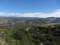
View of the Ibañez River Valley after the first sharp turn (Zig-Zag).
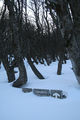
Arrival at the New Zealand Winter Camp: August 2017.
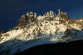
The needles of Cerro Castillo seen from the New Zealander Camp in August of 2017. Photo: Tobias Hellwig
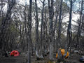
New Zealander camp under big Lengs that protect from strong winds. Photo: Marco Poblete


