![]()
Diferencia entre revisiones de «GPT21 - Lago Todos Los Santos»
(→Comments to Regular Packrafting Route) |
|||
| Línea 25: | Línea 25: | ||
}} | }} | ||
{{Table all GPTs}} | {{Table all GPTs}} | ||
| − | + | ||
| − | + | ==Recent Alerts and Suggestions== | |
| − | + | ==Season Section Log== | |
| − | + | ==Summary Table== | |
| − | + | ==Satellite Image Map== | |
| − | + | ==Elevation Profile== | |
| − | ==Section | + | ====Elevation Profile of Regular Hiking Route==== |
| − | == | + | [[File:profile GPT21.PNG|frame|center|Elevation Profile of Regular Hiking Route (2019)]] |
| − | + | ====Elevation Profile of Regular Packrafting Route==== | |
| − | + | [[File:profile GPT21-p.PNG|frame|center|Elevation Profile of Regular Hiking Route (2019)]] | |
| − | + | ||
| − | + | ||
| − | + | ||
| − | + | ||
| − | + | ||
| − | + | ||
| − | + | ||
| − | + | ||
| − | + | ||
| − | + | ||
| − | + | ||
| − | + | ||
| − | + | ||
| − | + | ||
| − | + | ||
| − | + | ||
| − | + | ||
| − | + | ||
| − | + | ||
| − | + | ||
| − | | | + | |
| − | + | ||
| − | + | ||
| − | + | ||
| − | + | ||
| − | + | ||
| − | + | ||
| − | + | ||
| − | + | ||
| − | + | ||
| − | + | ||
| − | + | ||
| − | + | ||
| − | + | ||
| − | + | ||
| − | | | + | |
| − | | | + | |
| − | + | ||
| − | + | ||
| − | + | ||
| − | + | ||
| − | + | ||
| − | + | ||
| − | + | ||
| − | + | ||
| − | + | ||
| − | + | ||
| − | + | ||
| − | + | ||
| − | + | ||
| − | + | ||
| − | + | ||
==Section Planning Status== | ==Section Planning Status== | ||
==Recommended Travel Period== | ==Recommended Travel Period== | ||
| Línea 92: | Línea 40: | ||
==Recommended Travel Direction== | ==Recommended Travel Direction== | ||
==Section Length and Travel Duration== | ==Section Length and Travel Duration== | ||
| + | ==Suitable Section Combinations== | ||
==Section Attractiveness== | ==Section Attractiveness== | ||
==Section Difficulty== | ==Section Difficulty== | ||
==Resupply== | ==Resupply== | ||
| − | ===Resupply | + | ===Resupply Town=== |
| − | ===Resupply | + | Town: Cochamó |
| − | ==Access to Route== | + | Cochamó is the gateway to La Junta, also known as the Yosemite of Chile, which is a popular climbing destination. |
| − | ==Permits, Entry Fees | + | ====Shopping: Food==== |
| + | Cochamó: It is possible to resupply out of the several small markets located here but somewhat expensive. There are several restaurants, including a delicious pizzaría, and many housing options. | ||
| + | Also along the road between Ralún and Cochamó, there are many lodgments and meal offers. | ||
| + | ====Shopping: Fuel==== | ||
| + | ====Shopping: Equipment==== | ||
| + | ====Services: Restaurants==== | ||
| + | ====Services: Laundry==== | ||
| + | ====Services: ATM and Money Exchange==== | ||
| + | ====Accommodation: Hostals and Hotels==== | ||
| + | ====Accommodation: Cabañas==== | ||
| + | ====Accommodation: Camping==== | ||
| + | ====Transport: Ground Transport==== | ||
| + | ====Transport: Ferries==== | ||
| + | ====Transport: Shipping Services==== | ||
| + | ===Resupply on the Trail=== | ||
| + | ====Location, Names, Available Items and Services==== | ||
| + | ==Access to Route and Return== | ||
| + | ===Access to Start=== | ||
| + | ===Return from Finish=== | ||
| + | ===Escape Options=== | ||
| + | ==Permits, Entry Fees and Right-of-Way Issues== | ||
==Regular Route== | ==Regular Route== | ||
===Regular Hiking Route=== | ===Regular Hiking Route=== | ||
| − | |||
| − | |||
| − | |||
===Regular Packrafting Route=== | ===Regular Packrafting Route=== | ||
| − | ==== | + | ==Optional Routes== |
| − | + | *Route description by Kara Davis after Season 2017/18: | |
| − | + | ||
| − | + | ||
| − | + | ||
| − | + | ||
| − | Route description by Kara Davis after Season 2017/18: | + | |
Alternate Route: We did not do approximately 37 km of the mapped section from Las Gaviotas to the middle of the paddle of Lago Todos Los Santos due to an attractive alternate. To reach the beginning of the alternate, it is possible to catch a bus from Puerto Varas to Ensenada along 225-CH. You can then hitch north along U-55-V to Puerto Klocker. Follow U-963 east from Puerto Klocker, to its terminus. There is a small cafetería and good camping located here on CONAF land. A well maintained trail winds around the north side of Volcán Osorno and ends at the west bank of Lago Todos Los Santos. Walk south along the lake to Petrohué which is a small town with some lodging but limited resupply options. There is a little café that serves expensive snack foods and burgers (3.500 CLP) and a pricey restaurant located in the hotel. From there, we paddled east on the Lago Todos Los Santos until rejoining the route. | Alternate Route: We did not do approximately 37 km of the mapped section from Las Gaviotas to the middle of the paddle of Lago Todos Los Santos due to an attractive alternate. To reach the beginning of the alternate, it is possible to catch a bus from Puerto Varas to Ensenada along 225-CH. You can then hitch north along U-55-V to Puerto Klocker. Follow U-963 east from Puerto Klocker, to its terminus. There is a small cafetería and good camping located here on CONAF land. A well maintained trail winds around the north side of Volcán Osorno and ends at the west bank of Lago Todos Los Santos. Walk south along the lake to Petrohué which is a small town with some lodging but limited resupply options. There is a little café that serves expensive snack foods and burgers (3.500 CLP) and a pricey restaurant located in the hotel. From there, we paddled east on the Lago Todos Los Santos until rejoining the route. | ||
| Línea 121: | Línea 82: | ||
The road is generally well maintained but frequently switches between 4WD and single track. The forest is fairly dense on either side, however camping is possible. GPT21H splits from GPT21RP right before Lago Cayutué. There is a potential campsite here next to an old wooden structure a couple hundred meters up the GPT21P route. Along the hiking route, there are several hundred meters of bushwhacking but the single track trail eventually reestablishes. This trail transitions to a gravel road at the top of the climb (elevation 500 m). There are limited camping options once on this road due to dense forest and an abundance of private land. This road ends at V-69, a paved road. Packrafters may paddle the Relocaví Estuary or roadwalk to Cochamó. | The road is generally well maintained but frequently switches between 4WD and single track. The forest is fairly dense on either side, however camping is possible. GPT21H splits from GPT21RP right before Lago Cayutué. There is a potential campsite here next to an old wooden structure a couple hundred meters up the GPT21P route. Along the hiking route, there are several hundred meters of bushwhacking but the single track trail eventually reestablishes. This trail transitions to a gravel road at the top of the climb (elevation 500 m). There are limited camping options once on this road due to dense forest and an abundance of private land. This road ends at V-69, a paved road. Packrafters may paddle the Relocaví Estuary or roadwalk to Cochamó. | ||
| − | + | ==Investigations and Explorations== | |
| + | ==Links to other Resources== | ||
| + | ==Alerts and Logs of Past Seasons== | ||
| − | |||
| − | |||
| − | |||
| − | |||
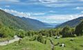
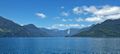
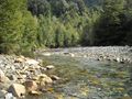
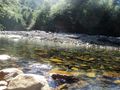
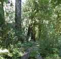
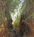
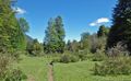
==Images== | ==Images== | ||
<gallery> | <gallery> | ||
| Línea 134: | Línea 93: | ||
File:Bahia ralun.jpg| | File:Bahia ralun.jpg| | ||
File:GPT_15_Lago_Todos_Los_Santos_109447481.jpg| | File:GPT_15_Lago_Todos_Los_Santos_109447481.jpg| | ||
| + | File:GPT_15_Lago_Todos_Los_Santos_109447390.jpg|thumb| | ||
| + | File:GPT_15_Lago_Todos_Los_Santos_31105869.jpg|thumb| | ||
| + | File:GPT_15_Lago_Todos_Los_Santos_109376389.jpg|thumb| | ||
| + | File:GPT_15_Lago_Todos_Los_Santos_109447280.jpg|thumb| | ||
| + | File:GPT_15_Lago_Todos_Los_Santos_109447287.jpg|thumb| | ||
| + | File:GPT_15_Lago_Todos_Los_Santos_109447294.jpg|thumb| | ||
</gallery> | </gallery> | ||
| − | |||
| − | |||
[[category:Greater Patagonian Trail]] | [[category:Greater Patagonian Trail]] | ||
Revisión del 07:43 27 oct 2019


| All GPT sections (click to show) |
|---|
|
GPT Section Articles
|
Recent Alerts and Suggestions
Season Section Log
Summary Table
Satellite Image Map
Elevation Profile
Elevation Profile of Regular Hiking Route

Elevation Profile of Regular Packrafting Route

Section Planning Status
Recommended Travel Period
Benefits of Hiking and Packrafting
Recommended Travel Direction
Section Length and Travel Duration
Suitable Section Combinations
Section Attractiveness
Section Difficulty
Resupply
Resupply Town
Town: Cochamó Cochamó is the gateway to La Junta, also known as the Yosemite of Chile, which is a popular climbing destination.
Shopping: Food
Cochamó: It is possible to resupply out of the several small markets located here but somewhat expensive. There are several restaurants, including a delicious pizzaría, and many housing options. Also along the road between Ralún and Cochamó, there are many lodgments and meal offers.
Shopping: Fuel
Shopping: Equipment
Services: Restaurants
Services: Laundry
Services: ATM and Money Exchange
Accommodation: Hostals and Hotels
Accommodation: Cabañas
Accommodation: Camping
Transport: Ground Transport
Transport: Ferries
Transport: Shipping Services
Resupply on the Trail
Location, Names, Available Items and Services
Access to Route and Return
Access to Start
Return from Finish
Escape Options
Permits, Entry Fees and Right-of-Way Issues
Regular Route
Regular Hiking Route
Regular Packrafting Route
Optional Routes
- Route description by Kara Davis after Season 2017/18:
Alternate Route: We did not do approximately 37 km of the mapped section from Las Gaviotas to the middle of the paddle of Lago Todos Los Santos due to an attractive alternate. To reach the beginning of the alternate, it is possible to catch a bus from Puerto Varas to Ensenada along 225-CH. You can then hitch north along U-55-V to Puerto Klocker. Follow U-963 east from Puerto Klocker, to its terminus. There is a small cafetería and good camping located here on CONAF land. A well maintained trail winds around the north side of Volcán Osorno and ends at the west bank of Lago Todos Los Santos. Walk south along the lake to Petrohué which is a small town with some lodging but limited resupply options. There is a little café that serves expensive snack foods and burgers (3.500 CLP) and a pricey restaurant located in the hotel. From there, we paddled east on the Lago Todos Los Santos until rejoining the route.
There is little boat traffic from approximately 13 km into the paddle of Lago Todos Los Santos to the take out since most traffic turns north at Isla Margarita. Camping is limited along the shoreline due to the thick foliage and steep grade. The few obvious beaches are privately owned, however the locals may allow camping on the land if asked nicely.
At the end of the paddle, there is an obvious beach just west of the river inlet with a house visible further back from the shore. DO NOT TAKE OUT ON THIS BEACH. It is private and the land owner has asked that hikers take out at the smaller public beach located approximately 1 km northwest from his land (to the right from the southbound paddler’s perspective). As of 2017 this has not yet been confirmed, however the caretaker said there is a road that begins at the public beach and leads back to the GPS route.
The road is generally well maintained but frequently switches between 4WD and single track. The forest is fairly dense on either side, however camping is possible. GPT21H splits from GPT21RP right before Lago Cayutué. There is a potential campsite here next to an old wooden structure a couple hundred meters up the GPT21P route. Along the hiking route, there are several hundred meters of bushwhacking but the single track trail eventually reestablishes. This trail transitions to a gravel road at the top of the climb (elevation 500 m). There are limited camping options once on this road due to dense forest and an abundance of private land. This road ends at V-69, a paved road. Packrafters may paddle the Relocaví Estuary or roadwalk to Cochamó.
Investigations and Explorations
Links to other Resources
Alerts and Logs of Past Seasons
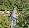
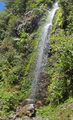
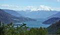
Images
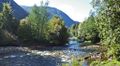
thumb|
thumb|
thumb|
thumb|
thumb|
thumb|


