Diferencia entre revisiones de «GPT40 - Glaciar Viedma»
| Línea 25: | Línea 25: | ||
}} | }} | ||
{{Table all GPTs}} | {{Table all GPTs}} | ||
| − | |||
| − | |||
| − | |||
| − | |||
| − | |||
| − | |||
| − | |||
| − | |||
| − | |||
| − | |||
| − | |||
| − | |||
| − | |||
| − | |||
| − | |||
| − | |||
| − | |||
| − | |||
| − | |||
| − | |||
| − | |||
| − | |||
| − | |||
| − | |||
| − | |||
| − | |||
| − | |||
| − | |||
| − | |||
| − | |||
| − | |||
| − | |||
| − | |||
| − | |||
| − | |||
| − | |||
| − | |||
| − | |||
| − | |||
| − | |||
| − | |||
| − | |||
| − | |||
| − | |||
| − | |||
| − | |||
| − | |||
| − | |||
| − | |||
| − | |||
| − | |||
| − | |||
| − | |||
| − | |||
| − | |||
| − | |||
| + | ==Recent Alerts and Suggestions== | ||
| + | ==Season Section Log== | ||
| + | ==Summary Table== | ||
| + | ==Satellite Image Map== | ||
| + | ==Elevation Profile== | ||
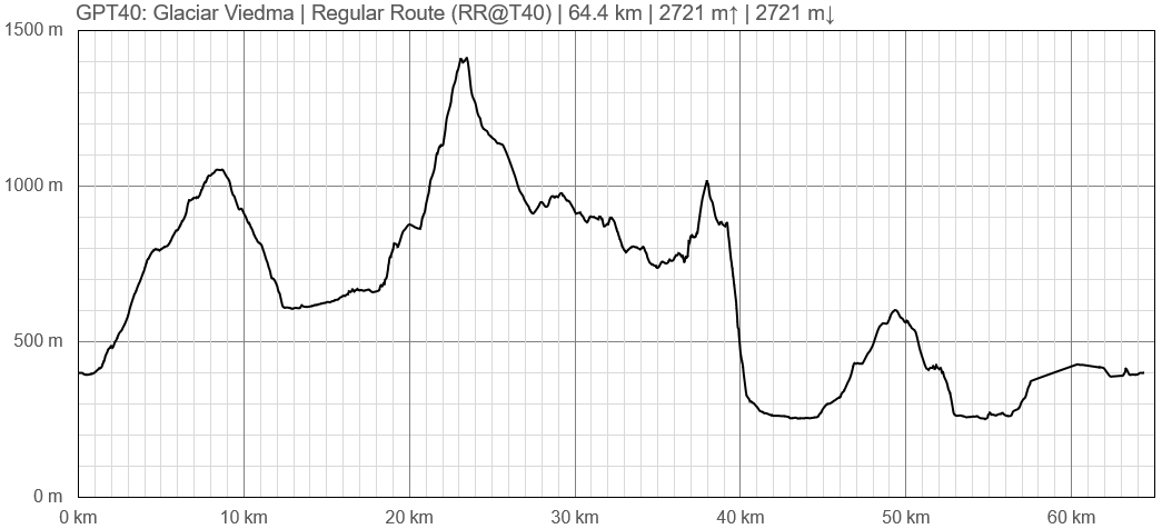
| + | ====Elevation Profile of Regular Hiking Route==== | ||
| + | [[File:profile GPT40.PNG|frame|center|Elevation Profile of Regular Hiking Route (2019)]] | ||
==Section Planning Status== | ==Section Planning Status== | ||
==Recommended Travel Period== | ==Recommended Travel Period== | ||
| Línea 87: | Línea 38: | ||
==Recommended Travel Direction== | ==Recommended Travel Direction== | ||
==Section Length and Travel Duration== | ==Section Length and Travel Duration== | ||
| + | ==Suitable Section Combinations== | ||
==Section Attractiveness== | ==Section Attractiveness== | ||
==Section Difficulty== | ==Section Difficulty== | ||
==Resupply== | ==Resupply== | ||
| − | ===Resupply | + | ===Resupply Town=== |
| − | ===Resupply | + | ====Shopping: Food==== |
| − | ==Access to Route== | + | ====Shopping: Fuel==== |
| − | ==Permits, Entry Fees | + | ====Shopping: Equipment==== |
| + | ====Services: Restaurants==== | ||
| + | ====Services: Laundry==== | ||
| + | ====Services: ATM and Money Exchange==== | ||
| + | ====Accommodation: Hostals and Hotels==== | ||
| + | ====Accommodation: Cabañas==== | ||
| + | ====Accommodation: Camping==== | ||
| + | ====Transport: Ground Transport==== | ||
| + | ====Transport: Ferries==== | ||
| + | ====Transport: Shipping Services==== | ||
| + | ===Resupply on the Trail=== | ||
| + | ====Location, Names, Available Items and Services==== | ||
| + | ==Access to Route and Return== | ||
| + | ===Access to Start=== | ||
| + | ===Return from Finish=== | ||
| + | ===Escape Options=== | ||
| + | ==Permits, Entry Fees and Right-of-Way Issues== | ||
==Regular Route== | ==Regular Route== | ||
===Regular Hiking Route=== | ===Regular Hiking Route=== | ||
| − | + | *Route description by Kara Davis after Season 2017/18: | |
| − | + | ||
| − | + | ||
| − | + | ||
| − | Route description by Kara Davis after Season 2017/18: | + | |
Notes to consider before beginning: GPT40 is more popularly known as the Huemul Circuit, a 57-kilometer trek in El Parque Nacional Los Glaciares. Before embarking, the national park guard requires that every hiker obtain a permit, bring required safety gear, and watch a slideshow about the circuit. The safety gear consists of a harness, 2 carabiners (one steel and one aluminum), slings, and 35 m of rope. Most of this gear can be rented at any outfitter in town, but due to liability reasons, the outfitters won’t rent rope. We went to the local ferretería to purchase this. All of this gear is used for two river crossings on zip lines. | Notes to consider before beginning: GPT40 is more popularly known as the Huemul Circuit, a 57-kilometer trek in El Parque Nacional Los Glaciares. Before embarking, the national park guard requires that every hiker obtain a permit, bring required safety gear, and watch a slideshow about the circuit. The safety gear consists of a harness, 2 carabiners (one steel and one aluminum), slings, and 35 m of rope. Most of this gear can be rented at any outfitter in town, but due to liability reasons, the outfitters won’t rent rope. We went to the local ferretería to purchase this. All of this gear is used for two river crossings on zip lines. | ||
| Línea 112: | Línea 76: | ||
After passing the refugio, the trail contours and then climbs to Paso Huemul. Make sure to look back and enjoy the last view of Glacier Viedma. The descent is very steep and at one point there is even a rope to downclimb. There are also plenty of woody bushes (manzanita?) to cling to as you lower yourself down the trail. After completing the descent, the trail is straightforward and easygoing. There is camping on the beach at the peninsula, Camping Bahía de Hornos. There is one more river crossing with a zip line at the lower Río Túnel, and from there it is easy walking to the end! | After passing the refugio, the trail contours and then climbs to Paso Huemul. Make sure to look back and enjoy the last view of Glacier Viedma. The descent is very steep and at one point there is even a rope to downclimb. There are also plenty of woody bushes (manzanita?) to cling to as you lower yourself down the trail. After completing the descent, the trail is straightforward and easygoing. There is camping on the beach at the peninsula, Camping Bahía de Hornos. There is one more river crossing with a zip line at the lower Río Túnel, and from there it is easy walking to the end! | ||
| − | + | ===Regular Packrafting Route=== | |
==Optional Routes== | ==Optional Routes== | ||
| − | == | + | ==Investigations and Explorations== |
| − | == | + | ==Links to other Resources== |
| − | == | + | ==Alerts and Logs of Past Seasons== |
| − | + | ||
| + | |||
| + | |||
[[category:Greater Patagonian Trail]] | [[category:Greater Patagonian Trail]] | ||
Revisión del 08:52 27 oct 2019
| All GPT sections (click to show) |
|---|
|
GPT Section Articles
|
Recent Alerts and Suggestions
Season Section Log
Summary Table
Satellite Image Map
Elevation Profile
Elevation Profile of Regular Hiking Route
Section Planning Status
Recommended Travel Period
Benefits of Hiking and Packrafting
Recommended Travel Direction
Section Length and Travel Duration
Suitable Section Combinations
Section Attractiveness
Section Difficulty
Resupply
Resupply Town
Shopping: Food
Shopping: Fuel
Shopping: Equipment
Services: Restaurants
Services: Laundry
Services: ATM and Money Exchange
Accommodation: Hostals and Hotels
Accommodation: Cabañas
Accommodation: Camping
Transport: Ground Transport
Transport: Ferries
Transport: Shipping Services
Resupply on the Trail
Location, Names, Available Items and Services
Access to Route and Return
Access to Start
Return from Finish
Escape Options
Permits, Entry Fees and Right-of-Way Issues
Regular Route
Regular Hiking Route
- Route description by Kara Davis after Season 2017/18:
Notes to consider before beginning: GPT40 is more popularly known as the Huemul Circuit, a 57-kilometer trek in El Parque Nacional Los Glaciares. Before embarking, the national park guard requires that every hiker obtain a permit, bring required safety gear, and watch a slideshow about the circuit. The safety gear consists of a harness, 2 carabiners (one steel and one aluminum), slings, and 35 m of rope. Most of this gear can be rented at any outfitter in town, but due to liability reasons, the outfitters won’t rent rope. We went to the local ferretería to purchase this. All of this gear is used for two river crossings on zip lines.
We were told that the rangers required hikers to bring their safety gear to the station before a permit would be issued. I would recommend that anyone who wants to do this circuit go to the rangers station the day before to watch the video and get any other necessary information about weather, conditions, etc. Since rentals can get expensive, renting the same day you leave and then going to the rangers station to show them your safety gear and get a permit seems to be the best course of action. The guard station is located on the south side of the Río Fitz Roy just across the bridge.
Most people hike the circuit clockwise (as the slideshow recommends). The trail begins just behind the rangers station and ascends up gentle grassy hills. It is fairly flat and well maintained. After passing Laguna Túnel o Tore, the trail deviates from the GPS route and loops to the first crossing of the Río Túnel on a zip line. During low water, it is possible to cross this river on foot by following the GPS track. After crossing the river, the trail climbs steeply to just above Glaciar Río Túnel Inferior. Along the south side of the glacier, the trail becomes hard to follow as it disappears in loose moraine. Walking on the edge of the glacier may be easier than trying to pick your way across the steep slope but be careful doing this.
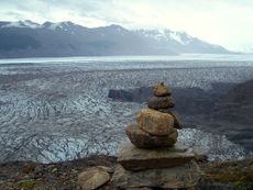
After passing the glacier, follow maintained switchbacks up the side of the mountain towards Paso del Viento, the high point of the circuit. For the next 20 km, expect amazing views of Glacier Viedma. I cannot speak to the quality of the trail descending from the pass because of the blanketing snowpack that was present during our trek, but the sections where the snow did melt looked maintained. There is a small refugio, Refugio Paso del Viento located at a pond about 3.5 km from Paso Viento.
After passing the refugio, the trail contours and then climbs to Paso Huemul. Make sure to look back and enjoy the last view of Glacier Viedma. The descent is very steep and at one point there is even a rope to downclimb. There are also plenty of woody bushes (manzanita?) to cling to as you lower yourself down the trail. After completing the descent, the trail is straightforward and easygoing. There is camping on the beach at the peninsula, Camping Bahía de Hornos. There is one more river crossing with a zip line at the lower Río Túnel, and from there it is easy walking to the end!


