![]()
GPT11 - Cerro Moncol


| All GPT sections (click to show) |
|---|
|
GPT Section Articles
|
Recent Alerts and Suggestions
- 11.12.2019 Sophie & Hendrik
Snow on top of Cerro Moncol made the regular route more difficult.
Season Section Log
- 2022-Feb-25 / RR Northbound / Romain / 3 short days
- If you cook on campfire or on wood burning stove you have better stay discrete because everything burnt some years ago and the landscapes are still marked.
- There are a lot of Araucaria trees. You can easily save food just by harvesting piñones on the floor following the path. I would recommend to not rely on it because it depends on the period, but there was plenty.
- Camp {11} [22.6/1461] : I loved this place. It was very comfortable with grass on the soil, almost flat, protected from the wind even if there is some in the valley, discrete, and I spent much time looking at the stars thanks to a good and warm (or at least not cold as it was the previous days) weather. To get water you have to walk 3 minutes following the point on the GPS which is precise
- Ford {11} [18.0/1199] : I had good time there, the weather was very good, the place is calm and good to rest, water is still cold but there is enough to wash if you want to
- From GPT-11C Start to Guallali it's now a Minor Road so it's very easy to follow and you meet a lot cars going in both directions, they just waved me.
- 2022-02-13 to 2022-02-14 | Veronika & Jo | GPT11 RR SOBO, with the optional sections 11-01 (ABCDE) from the pass to Termas Pelehue on GPT12
The MR out of Guallalí continues until about km 12 on RR-TL-V (another trail that's been jeep-tracked recently) where it veers off to the north. We found out two kilometers too late, but got back to optional route 11-C by CCing through some araucaria forest. This turned out to be a happy little accident, as, this way, we saw a family collecting things from the ground, which turned out to be piñones. Here is where we learned that the ripe cones are "café", and that the piñones just fall down when the cone is hit with a stick or a rock. It's basically nature's piñata (no etymological relation though!). Before getting back to the track, we found some low-hanging ripe cones, which sprinkled more piñones than we wished to carry. Got a nice free meal out of those we did pick up :)
Camped in one of the many camp sites deeper in the mountains.
The next day, we decided to skip the descent to Ranquil after the pass, instead taking the optional route 11-01 (ABCDE). 11-01 stays above 2000m on the slopes of the peaks to get to Termas de Pelehue on GPT12. We had food for three more days and the weather was excellent.
We regretted this decision. 11-01 is CC without a clear path. Initially you're walking diagonally on a 45° incline of scree and sand, which is technical and requires constant concentration to find the scree-free spots. Later on, you're going from lower-incline slope to slope with little high-incline "gulleys" in between (as usual on a mountain flank). At some point, we did not see how to cross such a gulley at the spot suggested by the track files. We decided to descend to the point where the gulley seemed to have a passable incline, to ascend back on the next slope. This turned out to be a mistake, as the slope became more inclined before the gulley became passable. In the end, we did a lot of clambering, I got some fresh cuts from sliding down high-incline scree, and we narrowly avoided some scary looking cliff edges at the low end of our slope. This was the most dangerous situation we got in so far, and we were not really prepared to handle it well.
I'm not blaming the track files: it was clear that it was high-altitude CC, and there was a waypoint warning of "demanding clambering" (though it should not be limited to "nobo"). Maybe going up the problematic slope instead of down would have been the better decision. Just be aware of the challenges this optional route brings. Definitely not doable in bad weather (you would just slide down to your death in some spots).
Note that OSM shows a trail a little to the west (a little lower on the slopes) of 11-01, which connects at the beginning and end. We think we saw this path at some points during our traverse. This may be the easier route to follow instead of sticking to the CC points (which was the superior strategy on all other CC sections so far ;)
There's a water spring at S 38° 06.178', W 071° 04.579'.
Anyway, we were happy to reach the Termas de Pelehue. Sub-par hot spring, but great scenery all around. You can camp there, we went for a small spot protected on most sides by mountain slopes: S 38° 07.407', W 071° 03.775'. There are some non-sulfur water springs as well as a warm river to wash up in the surroundings.
We continued on GPT12 for one day, getting back to Ranquil via the southern optional route 12-01. This way, we could catch the bus to Lonquimay the morning after (left at 07:55, there's a second one at ~17:00 Mo-We-Fr). Camped opposite the carabineros (on their suggestion) a bit behind the bus stop, close to the river.
- 2022-Jan-17/northbound RR / Molly and Melissa / 2 days
We arrived in Ranquil with the bus at 17, and walked about two hours to the hot springs where we camped. They are not very deep, but you can probably lie in them comfortably. Nicely warm. The ascent towards the pass next to Cerro Moncol follows the riverbed, and as previously noted, it's necessary to cross it multiple times. We were able to cross without getting our feet wet every time, though. The terrain before the pass is difficult, but after it immediately gets easier and the trail is easy to find. We were in a snowstorm and found it easily. The trail to Guallalí is pretty easy, a long way before Guallalí it becomes a gravel road. As described by others, there is a shop in Guallalí with VERY limited supply. It's next to the brown house of big planks, but you enter in front of the little red house to the right. Romina normally still offers accomodation, but when we were there she was leaving for an appointment in the evening and couldn't have us. She pointed us to the carabineros to camp, but they didn't want us there and told us to go to the camping ground "3 km" down the road. It turned out to be more like 12, and we ended up camping on a field some km from Guallalí
- 2021-Dec-03/NoBo RR/Marc Anthony
1 1/2 days. Took the bus from Lonquimay to Ranquil friday at 15:00 (leaves Monday, Wednesday and Friday). On arrival I met two fellow GPT-hikers. Started off in some pretty bad weather with hail and thunder, but it luckily passed after a few hours.
The first challenge I encountered was walking up the small river towards the first mountain pass (NoBo). To make my way up this section I had to cross the river countless times because of the difficult terrain by the river banks. Getting wet feet was inevitable. Afterwards I encountered a snowfield that leads up to the pass. Definitely possible to avoid the snow by walking along the edge, but I found it easier to just make my way up through the snowfield.
Continued on to guallalí where there is a mini-shop with very limited supplies. (There are no flags or signs that indicate there’s a shop but it’s by the brown house made of rustic wooden planks.)
Went directly on to GPT10 and made camp at the camping ground by el barco lake (5000 pesos) you can ask them to charge your electronics by the house where you pay. They didn’t sell any food.
- 2020-Jan-28 / Martin / Optional route 5 route southbound
4 days. 120 km. Because of bad weather forecast in the high parts of the cordillera, with strong winds, rain and even snow, we opted to take Alternative route 5 from Chenqueco to Lonquimay Volcanoe. A lot of road walking at the begining but the scenery and trail in the National Park were really amazing and worth it. Beware that in the traverse through the volcanoe to Corralco Ski Resort, there is no water and also difficult to camp. High winds and a lot of rain at the end. We checked many hostels in Lonquimay and the most convenient for us, was Hostal Nativo close to the main square.
- 23 Jan 2020 Frank RR (mostly) Southbound.
2 days & continued to GPT12 At Pass 2180 wind & rain came in, I diverted onto OH-CC-A@11-03-#001 as described by Linda. Snowfields were old & undercut by stream leaving tunnels 5M deep, definitely not safe to slide on. Walked on edge of snowfields or a little above them on right. Then you enter a gorge, it is best to stay close to the stream & only leave the gorge if you must. In to Ranquil, nothing there apart from Carabineros & no traffic. From Ranquil I continued on OH-TL-V@12-01-#001 to GPT12
- 2020-Jan-23 / Ty & America / RR SOBO / Guayali - Termas de Pelehue
Short & Beautiful. 4:00 Bus Ralco - Guallali. Arrived at carabineros after 8. Luckily they let us camp outside. TONS OF FLIES, so be ready for that. The thermal pools at Pelehue are up by the fumarole. The traverse over there is gnarly, steep, slippery, all the good stuff. Quite small, but with an AMAZING view. The lower one seemed fine to get in, we didn’t as we wanted to make it to the next hot springs on section 12.
- 2020-Jan-17 / Martina & Ivo / Regular route southbound / Start: Guallalí, End: Termas de Pelehue
2.5 days. We went from Ralco to Guallalí by Fletes (see section "To section start"). It's a bit expensive but we didn't want to take the bus at 16:30, arriving late. Beautiful section. The first hot springs are worth the detour if you have time to clean them and dig a bigger pot (would take you approx. 2h), otherwise you just have a warm foot bath. After the pass we took the optional route #002 leading back to the regular route, then we switched some times between optional and regular route and finally took the optional route directly to the Termas de Pelehue. This part is quite demanding as there are some landslides where you have to find your way through somehow. The hot springs are gone due to lack of maintenance.
- 9-Jan-2020 / Matus & Anna
We combined sections 11 and 12. It took us 5 days including one zero because of weather. Patagonia showed us bit of it's potential in these two sections. All walked trails were in good condition and CC sections pretty easy to navigate. In the sadle of section 11, because of strong wind, poor visibility and fresh snow and ice we were forced to take optional to the valley. There is a big snowfield, I don't recomend sliding on it all the way. It the lower parts there were big holes into the stream. From Ranquil we took optional #002 because we didn't want to climb back up. Uphill is more a minor road, downhill nice trail. After a laguna we took a optional to the Pass 2180 and road around the Pehuenche Extortioner. We needed to get down from elevation ASAP bacause of wind. We passed puesto early in the morning and no one was around. After rainy day everything above 2000m was white. We took trail to pass 1920m which was just with bit of fresh snow and then took minor road #001 down to valley. So I have no idea about the rest of the trail. Edit: adding a picture from the last sadle 1920m, we did after "rainy" day.
Linda 27/12/2019 - 28/12/2019 2 days Southbound Regular hiking route until the pass 2180 meters and then Option 3
Nice section ! After the pass, I decided to go down along Option 3 that goes into the canyon. Lot of snow at the beginning, but that was fun cause the slope was not very steep and I could use my bag raincover as a sledge to go down!
Then, I ended up into the canyon, crossing the river at least 20 times but no problem cause the water level is low and the river is tight (compared to GPT07 for instance).
The only difficulty was once the canyon becomes too tight and I had to find a way up and had to face a landslide. Just one part of 5 meters wide but quite dangerous cause very sleepy with the rocks falling down.
After, back into the canyon until I could join the Regular Hiking route. No difficulties until Ranquil.
Was lucky to find people with a car who dropped me in Lonquimai cause I had to resupply. Otherwise, only 3 Buses a week from Ranquil (no tiendas to resupply) to Lonquimai = Monday, Wednesday, Friday
Supermercado with everything to resupply and accommodations in Lonquimai
- 12.12.19 / Sophie & Hendrik / 4.5 days (19 walking hours) / Northbound / Regular Hiking Route.
In total we were 5.5 days on the trail, of which we spend 1 in the tent due to bad weather. On Cerro Moncol there was still some snow, which made us very slow, as we either had the options to walk on steep snow or walk higher up in more difficult terrain. Rivercrossings were no problem.
We liked: The amazing views, the condors we met at the northern part of the pass (they came very close to us), the mountain crystals of which there are plenty on the northern side of Cerro Moncol.
We did not like so much: The higher difficulty due to the snow in some parts.
Summary Table
| GPT11: Cerro Moncol | Hiking | Packrafting | |||||
| Group | C: Zona Pehuenche | Total | 40.5 km | 15 h | - | - | |
| Region | Chile: Bío Bío (VIII) & Araucanía (IX) | Trails (TL) | 29.0 km | 71.6% | - | - | |
| Start | Guallali (Carabiñeros) | Minor Roads (MR) | 5.8 km | 14.2% | - | - | |
| Finish | Ranquil (Carabiñeros) | Primary Roads (PR) | - | - | - | - | |
| Status | Published & Verified | Cross-Country (CC) | 5.7 km | 14.2% | - | - | |
| Traversable | Dec - Mar (Maybe: Nov, Apr) | Bush-Bashing (BB) | - | - | - | - | |
| Packraft | Only Burden | Ferry (FY) | - | - | - | - | |
| Connects to | GPT10, GPT12 | Investigation (I) | - | - | - | - | |
| Options | 313 km (5 Options & Variants) | Exploration (EXP) | - | - | - | - | |
| Hiking | Packrafting | Total on Water | - | - | |||
| Attraction | 5 (of 5) | - | River (RI) | - | - | ||
| Difficulty | 4 (of 5) | - | Lake (LK) | - | - | ||
| Direction | Both ↓↑ | - | Fjord (FJ) | - | - | ||
| Comment | - | ||||||
| Character | Araucaria Forest, Alpine Terrain, Summit Ascents, Hot Springs, Mountain Pastures, Pehuenche | ||||||
| Challenges | Exposure to Elements, Clambering, Demanding Navigation | ||||||
Satellite Image Map
Elevation Profile
Elevation Profile of Regular Hiking Route

Comments to Regular Hiking Route
Elevation Profile of Regular Packrafting Route
[[File:|frame|center|Elevation Profile of Regular Hiking Route (2019)]]
Section Planning Status
Recommended Travel Period
Benefits of Hiking and Packrafting
Recommended Travel Direction
Section Length and Travel Duration
Suitable Section Combinations
Section Attractiveness
Section Difficulty
Resupply
Resupply Town
Lonquimay (from Ranquil) - Supermercado Espinoza next to the bus terminal has most things. A little shop on the left hand shortly after the bus terminal when walking from the bus terminal towards the center has gas. The shop has different air mattresses, clothes and some outdoorsy things in the windows. There's also a ferretería that might have. Several accommodation options
Shopping: Food
Shopping: Fuel
Shopping: Equipment
Services: Restaurants
Services: Laundry
Services: ATM and Money Exchange
Accommodation: Hostals and Hotels
Accommodation: Cabañas
Accommodation: Camping
Transport: Ground Transport
Transport: Ferries
Transport: Shipping Services
Resupply on the Trail
Location, Names, Available Items and Services
Access to Route and Return
Access to Start

- Guallali
(2020-Jan)
Bus Ralco-Guallalí 16:30 Mon-Sat, 9PM Sun. (~2.5h) The bus leaves Los Angeles terminal rural around 2PM Mon-Sat, 7:30PM Sun, continuing to Ralco & Guallali
Fletes: 4x4 Cars in front of the supermercado. They drive you everywhere. CLP 80'000 to Guallalí, but if you find one going there anyway the price is much lower ;-)
- Ranquil
(2022 Jan) Bus from Lonquimay Monday, Wednesday and Friday at 15 Other days bus to Troyo can take you most of the way, but hitching the rest might be difficult
Bus from Ranquil to Lonquimay Monday, Wednesday and Friday 7:30
Return from Finish
Escape Options
Permits, Entry Fees and Right-of-Way Issues
Regular Route
Regular Hiking Route
Regular Packrafting Route
Optional Routes
GPT11 Option 5 - NOBO - Beg. December 2021 - Franck & Damien
> Be aware there are only 2 water spots on the road around the volcano One at the start (tap by the conaf barrack) and a very small one at the camp before entering the scoria field (not sure if water flows after december). Make sure you load liters of water, esp. in summer (heat + exposure to sun) > Plenty of water (snow melt) once you passed the volcanoe. > The TL from Contracto bridge to Communidad Chenqueco is now a kind of MR, we crossed several 4WD there (? !!). There is plenty of water there.
GPT11 Option 5 southbound (15-Jan-2020 / Maddie & Tom)
3 days, 120km walking around Volcán Lonquimay. Given section 11 was not feasible due to high levels of snow we took took Optional Route 5. For us it was 5 star scenery. It is beautiful and the trail is very easy to follow with trail markings in the CONAF park. We found it to be quite a quick section as a result of the easy navigation and good trail quality. Good resupply options in Lonquimay (we stocked up on food as well as bought some new socks and more 95% alcohol for our stove).
Investigations and Explorations
Links to other Resources
Alerts and Logs of Past Seasons
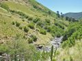
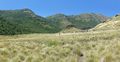
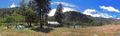
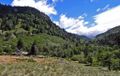
Images
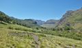
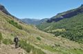
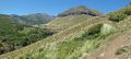
Laguna Marinanqui
Laguna Marinanqui
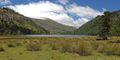
Laguna Marinanqui
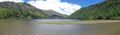
Laguna Marinanqui
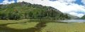
Laguna Marinanqui
thumb|
thumb|
thumb|
thumb|
thumb|
thumb|
thumb|
thumb|
thumb|


