![]()
ENG:Glaciar San Francisco / Monumento Natural el Morado

| |


|
|
|
| |||||||||||||||||||||||||||||||||||||||||||||||||


 Attention: do not commit the usual mistake of mixing-up this rout with the “GLACIAR DEL MORADO” located just a little to the east. The path shown here is located in the “Natural el Morado” and also appreciates the south side of the “CERRO MORADO” (origin of the mix-up) but the “San Francisco” is the glacier that can be seen. Attention: do not commit the usual mistake of mixing-up this rout with the “GLACIAR DEL MORADO” located just a little to the east. The path shown here is located in the “Natural el Morado” and also appreciates the south side of the “CERRO MORADO” (origin of the mix-up) but the “San Francisco” is the glacier that can be seen.
|

.jpg)


Season
- Trekking: The best season for this trek is between the months of october and may, although the ideal is from november to december
- Randonnée and skiing: Between June and late September. Even then, depending on the year and the last snowfall, is quite possible that it will be necessary to load the skis along the first part.
Access
Car
From the intersection at las Vizcachas (Avenida Camilo Enríquez and Avenida Eyzaguirre, km 0), take the road G-25 towards Cajón del Maipo, and follow it until km 65.1 (asphalt ends in the km 66.3 just before Lo Valdés) where there is a bifurcation. To the left, it leads to Baños Morales along a dirt road, located on the other side of the El Volcán river. Between June and September this road might be closed if there have been recent snowstorms. You can check the road status with Carabineros at San Gabriel (+56228611008 y +56228612290) although their answers tend to be on the conservative side.
Public busses to Cajón del Maipo
- Public busses (subsidized): El Alfalfal – San José de Maipo; Baños Morales (Lo Valdés) – El Volcán – San José de Maipo and El Volcán–San José de Maipo cost CLP$1200 (US$ 1.2 as of April 2024). It can cost as little as $300 for shorter distances.
- Turmaipo: From October to January first, Saturdays, Sundays and holidays. Daily in January and February. Departures at 7:30 AM and from Baños Morales at 18:000. It departures from Terminal de Metrobuses Bellavista de la Florida, platform E, or from Las Mercedes (Puente Alto) around 7:50. In San José de Maipo at about 8:35, to finally reach Baños Morales around 10:15. CLP$8000 (US$ 8.1 as of April 2024) round trip to Baños Morales, cheaper for shorter distances. Phone: +56228424208, +56222830082, +56228611518, cell +56982896718
- Buses TurMarzur: Phone +56993357800
Private vans to Cajón del Maipo
- Turismontaña: +56991219203
- Baños Morales: CLP$10000 (US$ 10.2 as of April 2024) round trip, per person, $12000 if you return a different day.
- Embalse El Yeso: CLP$10000 (US$ 10.2 as of April 2024) per person
- Turismo Arpue: CLP$10000 (US$ 10.2 as of April 2024) per person. Bookings at least 24 hours in advnace +56222117165 - +56226818475 cel: +56999320108
Both companies depart from Baquedano Metro Station (red and green lines), at the side of Telefónica building. The departure is at 7:30, to reach Baños Morales at about 10:00.
Route description

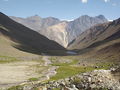
From CONAF the route ascends abruptly for about 45 minutes. The road entrees the valley, crossing on many occasions an old road that zig-zags. Close to an hour later, once the trail has already remounted the initial moraine, the valley stretches and “Aguas Panimávida” appears, a patch of half-flooded grass with mineral water ponds. From now on the slope decreases and the trail continues to the north, with the imposing south face of “El Morado” as the background. After about two hours from mineral waters, the “Laguna de Morales” is reached (commonly confused with “Laguna del Morado,” for this lagoon see Glaciar del Morado). It's a nice destination but it is recommendable to continue another hour to the north, approaching the bottom of the glacier “San Francisco” (2.800 meters above sea level.) The trail is a little less clear, the slope increases and it's more likely to find snow on this part if you go during late spring or early summer.
Estimated Time
At a normal pace, this trek should take about 5 hours between CONAF and the viewpoint of the glacier. However, what is meant by "lookout" is not a well-defined point, but rather an area where you can appreciate and photograph the impressive ice caves formed by the glacier.
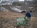
Authorization/Fees
This trekking requires an entree fee to the “Monumento Natural el Morado” (March 14th 2015) Adults: $2.000 per person Children: $1.000 Seniors: free
The people who enter must register when paying the entrance and then must notify their departure in the same place. It is not allowed to spend the night inside the Natural Monument, although it can be done in many places nearby.
Schedules
From October to April: Entrance from 8:30 to 13:00 hrs exit until 18:00 hrs From May to September Entrance from 8:30 to 12:30 hrs exit until 17:00 hrs
Guides
Agencia de Ecoturismo y montaña, Montaraces del Sur, +56942697948, mail: Montaracesdelsur@gmail.com
Tips
- There are bathrooms in access. Inside the monument rocks can be used to hide, but it is very important to carry a bag to take the toilet paper used, because it is a busy place and seeks to prevent small landfills to form inside.
- Do not try to climb on the glacier as it’s possible that an accident might occur especially if you don't have the right equipment.
Excursions near by
- Cerro San Francisco: This route runs along the north side of the hill, which doesn't belong to the Morado Natural Monument.
- Cerro Morado: This route also runs along the visible face from the Natural Monument El Morado, but the face that is reached following the Morado glacier trek.
Glaciology observation station
In August 2012, the USGS installed a glaciological station to measure the behavior of the glacier San Francisco. It is located at 3200 meters. Press release.
Photo gallery
Glaciar San Francisco by Mario El Russo
Aguas Panimávida by Mario El Russo
Aguas Panimávida at the end of the summer. On the background Retumbadero and Cerro Diablo


Weather
To see the full list of 688 routes of trekking and mountain climbing in Chile in spanish, click here
| ||||
| Trekking Atacama | ||||
| Trekking Norte Chico | ||||
| Trekkings: | ||||
| Cumbres: | ||||
| Trekkings: | ||||
| Cumbres: | ||||
| Trekkings: | ▲ ENG:Gran Salto del Río Olivares ▲ ENG:Glaciar San Francisco / Monumento Natural el Morado ▲ ENG:Glaciar del Morado | |||
| Cumbres: | ||||
| Trekkings: |
| |||
| Cumbres: | ||||
| Trekking Rancagua | ||||
| Trekking San Fernando | ||||
| Trekking Curicó | ||||
| Trekking Talca | ||||
| Trekking Linares | ||||
| Trekking Chillán | ||||
| Trekking Concepción | ||||
| Trekking Los Angeles |
| |||
| Trekking Zona lacustre | Trekking Temuco | |||
| Trekking Valdivia | ||||
| Trekking Osorno | ||||
| Trekking Puerto Montt | ||||
| Trekking Chiloé | ||||
| Trekking Patagonia | Trekking Chaitén | |||
| Trekking Coyhaique | ||||
| Trekking Cochrane y Villa O`Higgins | ||||
| Trekking Puerto Natales | ||||
| Trekking Punta Arenas | ||||
| Trekking Tierra del Fuego | ||||
| Trekking Isla de Pascua | ||||
| Trekking Archipiélago Juan Fernández | ||||