![]()
Greater Patagonian Trail

General Description

To be issued.
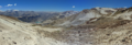
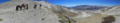
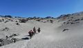
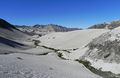
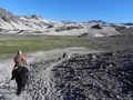
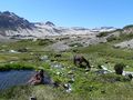
Images
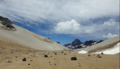
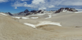
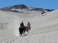
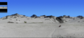
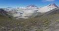
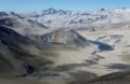
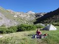
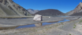
Here you find a selection of images from all 16 sections of the Greater Patagonian Trail.
Trail Sections
The entire trail is broken into 16 sections that require between 3 to 10 days each. Every section connects seamless with the following section and starts and ends near a road with public transportation. Therefore each section can be hiked as an individual trail or several sections can be combined to a longer trip depending on how much time you want to hike.
Expected Duration
Hiking the complete trail requires approx. 90 to 120 days. This inculdes some rest days and resupply bus trips to nearby towns.
Recommended Season
If you plan to do the entire trail starting with section 1 you should leave in December.
On the first sections several high passes and rivers need to be crossed. Snow and high river-water-levels during snowmelt may make this difficult and dangerous until early December. Therefore leaving before December may put you in risk when crossing rivers and passes; if you leave after December you may be surprised by the heralds of the winter before reaching the finish.
If you have a packraft and you do not insist in hiking all trail sections in the correct sequence you have more options when and where to start. You may in example set out already in October or November with section 11 in Coñaripe (first packraft section). This also give you the advantage of floating down the river Caucuá with comfortable high river-water-levels during snow melt (section 11). Once your reached the finish of section 16 your can travel by bus to the start of section 1 and complete the trail without carrying the packraft any more.
Trekking Direction
The generally recommended trekking direction is southbound even if most sections can be hiked in either direction. Some sections require a entrance permit if you hike northbound. This limitation applies to section 1, 2-3, 12. Also for section 11 the southbound limitation applies. Only in this direction you can float down the river Caucuá with your packraft.
Logistical Considerations
There are no proper shops along the first seven sections of the trail. The first regular food store on the trial comes after 600 km at the finish of section 7. Therefore reaching the finish of a section gives you the opportunity to take a bus and to travel to the next village or town to resupply. A true through-hike would require the setup of food depots on strategic points along the route.
The product range, in particular the supply of dehydrated trekking food, is limited or non-existing in smaller villages and towns. If you prefer to have some special stuff that you find only in Santiago or that you bring with you from overseas you have the following option: You can pack a box with food and gear in Santiago and send with one of the mayor bus companies to yourself to a town where you plan a resupply stop. The bus company will store your package until pick it up. There you can take out of your box what you need and resend the box to the next resupply town.
As non-Chilean tourist with a regular tourist visa you can stay up to 90 days in Chile. The easiest way to renew your visa is travelling to Argentina before you complete your 90 days and returning a few days later to Chile. On re-entry you will normally be granted another 90 days.
Recommended Equipment
A packraft is a light-weight inflatable boat designed to be carried in backpack when not needed but to carry the backpacker over leaks and rivers when he needs it. A packraft is recommended for sections 10, 11, 12, 13, 15 and 16.
Here you find some images of our packraft.
GPS File for Trekking
The KMZ file displayed on the satellite map above is optimized to provide a good overview but does not include waypoints and detailed information for hiking. Therefore the file below should be downloaded and used if you actually plan to hike a section or the entire Greater Patagonian Trail.
The file is organized in folders and subfolders for a better overview in particular when viewing and organizing the trail on a computer. There is one folder for each section and each section contains a subfolder for waypoints and a subfolder for tracks.
Waypoints
The waypoints are named with the item of interest of this location.
Common items are: Start, River Crossing, Water, Pass, Camp, Refuge, Bus Stop (Finish) …
A running number is added in brackets to be able to refer in the trail description to specific waypoints.
Example waypoint name: “Start (GPT01-WP001)”
- Start: Item of interest, in this case the start of section 1
- GPT: Greater Patagonian Trail
- 01: Section 1
- WP: Waypoint
- 001: Running number
Tracks
The track of each section is broken into smaller segments to differentiate between different trail types.
Used trail types are:
- 0: Cross country (no visible trail)
- 1: Hiking trail or horse trail
- 2: Minor dirt road with no or insignificant traffic (also abandoned road or closed private road)
- 3: Mayor dirt road with moderate traffic
- 4: Paved road
- ?: Not verified trail section (Remains to be hiked and recorded by GPS to update the trail file)
- L: Lake (Packraft)
- R: River (Packraft)
- S: Sea (Packraft)
- F: Ferry
Example track name: "GPT01-TR006-1"
- GPT: Greater Patagonian Trail
- 01: Section 1
- TR: Track
- 006: Running number
- 1: Trail type, in this exmaple its a hiking trail or horse trail
A "X" is added to the track name for optional side trips or alternative trails.
Example track name: "GPT01-TR007-0-X"
The "X" at the end means that this is an optional side trip. In this example its the optional climb to the summit of the volcano Descabezado Grande.
Verifications, Additional Options and Extensions
To be issued.
Section 1: Volcán Descabezado
- Duration: 6 to 8 days
- Distance: 103 km
- Ascent: 4970 meters ↗
- Descent: 4870 meters ↘
- Option 1: Climb to the summit of the volcano Descabezado Grande
- Duration: 1 to 2 days
- Distance: 16 km
- Ascent: 2030 meters ↗
- Descent: 2030 meters ↘
- Option 2: Explore to hidden lakes
- Duration: ½ to 1 day
Summary
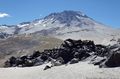
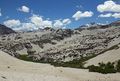
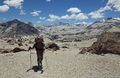
The first stage of the Greater Patagonian Trail gets you right into a mind-blowing volcanic theatre. The landscape is transformed by numerous powerful eruptions of the volcano Descabezado Grande and it’s equally potent smaller brothers in the surrounding. During the last major outbreak in 1932 the Quizapu; a parasitic crater 6 km south of the main crater; vomited an estimated 25 cubic kilometer of lava and volcanic ash.
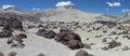
After leaving the forest you will step through endless fields of pumice, climb three passes and cross a 4 km wide lava river. The struggle is rewarded with amazing outlooks, deep blue lakes and lagoons that suddenly pop in a surreal scenery and two thermal springs. Here you can soak up heat during a freezing night while admiring a sky full of stars. You can even cook your meal on one of the hot steam vents.
As an option your may climb to the 3900 m high summit of the “Great Decapitated”; this is what Descabezado Grande means. It’s a demanding long but technically uncomplicated ascent.
You can also explore two hidden lagoons; one that fills an ancient crater and a second one that was dammed up by another smaller volcano. Both lakes are not far of the trail near a scenic camp site.
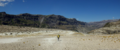
Images
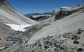
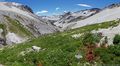
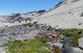
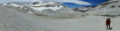
Here you find a selection of images of section 1 of the Greater Patagonian Trail.
Expected Duration
The trail can be hiked in 6 days but plan some contingency in case of bad weather or if you suddenly fall in love with one of the amazing places on the route. If the climate does not favor you, than you should not attempt to cross the passes. In this region bad weather normally does not last long so you are probably better off siting out a bad day.
If you are tempted to get up to the summit of the Descabezado Grande (GPT01-WP028) add two more days. The climb can be done in one long day or split up in two days when camping one night a bit further up.
Recommended Season
This traverse is best be hiked between December and April. After a mild winter with less snow than usual you may already set out in November but be aware that some rivers may be impassible high during snowmelt (in particular GPT01-WP018 and GPT01-WP019). If you plan to get up to the summit of the Descabezado Grande without carrying crampons you should have better chances at the end of December or later when most of the snow is gone.
Trekking Direction
The treck can be hiked in either direction but doing it from South to North requires an entrence permit from the hydropower station Cipreses (See Permits and Entrance Fees). Therefore southbound is the recommended direction.
Permits and Entrance Fees
CONAF does register all trekkers at Parque Ingles (GPT01-WP004) but does not charge an entrance fee. Camp fires are not permitted within the national park that reaches from Radal (GPT01-WP001) to the Laguna las Ánimas (GPT01-WP013).
If you want to see the cascades Siete Tazas about 7 km after the start in Radal you are charged a rather high entrance fee depending if you are a national or a foreign tourist. If you don’t want to spend the money and the time don’t worry; you will see plenty more cascades for free on the Greater Patagonian Trail.
If you wish to hike this trail in reverse from South to North you need to request a entrence permit in advance from the hydropower station Cipreses. If you hike the trail as described from North to South you will enter the property “from behind” without noticing it. Once you reach one of the permanentely manned gates they can’t send you back over the mountains but need to let you leave the compound. In contrast, if you try to enter without a permit you are probably turned back.
Inhabitation and Tourism
The last settlement on the trail is Parque Ingles about 10 km after Radal. This is also the last opportunity to spoil yourself with a good meal in a restaurant and to buy some goodies. On the trail that follows are only two occasionally used puestos; one at the Termas de Azufre (GPT01-WP020) and a second one at the Base Camp Descabezado Grande (GPT01-WP024). The first 20 km from Radal to El Bolson are a popular hiking destination for national tourists. Some go up to the Laguna las Ánimas but few continue beyond this point.
The Base Camp Descabezado Grande is frequently visited by national and international tourists coming from Vilches Alto. Also horseback tours often stop and rest here.
Hardly any hikers take the scenic trail from the Base Camp Descabezado Grande via the Laguna Caracol to the hydropower station Cipreses. It’s a hidden gem.
Food Supply
You need to carry all the food for the entire trail. There is no food supply after Parque Ingles. If you meet arrieros at one of the Puestos you may ask for some goat or lamb meet but if you are not ready to take an entire or at least half an animal they may be reluctant to sell.
Water Supply
Refill your water supply at the marked river crossings and the camps. In between these waypoints your will find only ocasinally some trinking water because water trickles away easily into the volcanic soil. Drinking the water of the hot springs is not recommended because it can upset your stomach. Better take fresh water from the river or a cold spring nearby.
When climbing the Descabezado Grande take plenty of water from the base camp in particular if you plan to spend one night higher up. You may refill your supplies with snow near the summit.
Maps
The electronic map Topo Chile Deluxe from Garmin shows the contours precisely but some lakes and smaller river are incorrect displayed. Only few trail sections are integrated. Some of the “Alleys” of this electronic map are far off the true position or inexistent. You should use the Greater Patagonian Trail data files for navigation.
The paper trekking map “Condor Circuit” with a scale of 1:50’000 shows the trail from Parque Ingles to the Base Camp Descabezado Grande. This map is a useful supplement to the electronic map in particular if you need to abort the trip. In this case this map can guide on the shortest possible trail out of this isolated volcanic area i.e. to Vilces Alto.
Difficulty
The isolation and the high passes make this a rather difficult but rewarding trail. Good orientational skill are required because hardly any signposts are placed and some parts of the trail are cross country.
Access to Start
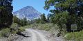
The trail starts in the tiny village Radal near the cascade "Siete Tazas".
During the main season in January and February several buses go from Molina and Curico to Radal and some even go all the way to Parque Ingles. Outside of the main season there is only one daily bus from Molina to Radal leaving in the afternoon from the rural bus station in Molina.
Return from Finish
This trail section finished at the Route 115 to Talca.
All spring and summer run four buses per day on the route 115 between La Mina and Talca. La Mina is about 4 km up the road from the hydropower station Cipreses. In La Mina is the Chilean border control post and a thermal spring. Simply wait at the main road at one of the unmarked bus stops for the bus to Talca and call the attention of the bus driver when he approaches (GPT01-WP043 or GPT01-WP045). You may also try to hitchhike.
From where to return best depends if you want to connect with the next section of the Greater Patagonian Trail without leaving any gap. If you insist on hiking every step of the trail you should take the bus stop at the El Melado junction (GPT01-WP043). At this junction starts the section 2 of this long distance trail.
If you don’t mind to skip the less atractive 10 km streach along the Maule River then you can go straight to the Route 115 and take the closest bus stop (GPT01-WP045). You may also try to get a lift with one of the hydropower station workers from main gate to Talca or to San Clemente (GPT01-W044). From San Clemente leave frequent minibuses to Talca.
Suggested Stages
To be issued.
Waypoints
Start (GPT01-WP001): Start in Radal at final bus stop. Only in January and February some busses continue to Parque Ingles.
Shop (GPT01-WP002): Small shop with basic supplies in Radal. Good to get a beer and some extra goodies for the night but not to supply you for the trip.
Camp $ (GPT01-WP003): Nice, reasonable priced camp site in Radal. Recommen¬ded place for the first night if arriving in the evening.
Shop & Restaurant (GPT01-WP004): Parque Inglés with kiosk and a cosy restaurant about 10 km after the starting point. Last chance to enjoy the pleasures of civilisation before heading into the wilderness.
Diversion, CONAF & Camp $ (GPT01-WP005): The hiking trail starts left. You should register at the CONAF office. There is a camp site nearby.
River Crossing (GPT01-WP006): Easy river crossing.
River Crossing (GPT01-WP007): Easy river crossing.
River Crossing (GPT01-WP008): Easy river crossing.
River Crossing (GPT01-WP009): Easy river crossing.
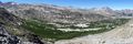
Camp (GPT01-WP010): There are some nice camp sites on the meadows of El Bolson. Inside the national park CONAF does not permit camp fires.
Refuge (GPT01-WP011): Basic refuge in El Bolson that can shelter for up to 4 persons.
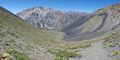
Pass 2260 m (GPT01-WP012): First pass with nice view back into the Valle del Indio. After this pass comes a 2 km levelled section before ascending to the second pass.
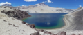
Lake (GPT01-WP013): Laguna Las Ánimas. You may camp at the lake but there is little shelter from wind.
Water (GPT01-WP014): Clear fresh water.
Pass 2560 m (GPT01-WP015): Second pass with nice view towards Laguna Mondaca.
Camp (GPT01-WP016): Probably the best camp spot near Laguna Mondaca with water, fire wood and some wind protection.
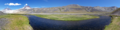
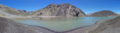
Lake (GPT01-WP017): Laguna Mondaca.
River Crossing (GPT01-WP018): Difficult river crossing during snowmelt and after heavy rain. The river often changes it's bed therefore look for the optimal place to cross. Yon need to cross the river to avoid rocky terrain ahead.
River Crossing (GPT01-WP019): Difficult river crossing during snowmelt and after heavy rain. The river often changes it's bed therefore look for the optimal place to cross.
Hot Spring, Camp & Puesto (GPT01-WP020): Termas de Azufre. Excellent hot spring with several small pools. You may need to adjust the temperature by regulating the hot water inlet flow. No fire wood but you may heat water and food at the hot steam vents (follow the noise). Good camp site if you tolerate the sulphur smell. The posteros arrive in January.
River Crossing (GPT01-WP021): Moderate difficult river crossing. Yon need to cross the river to avoid steep loose pumice fields ahead.
River Crossing (GPT01-WP022): Easy river crossing.
Pass 2700 m (GPT01-WP023): The highest point of the entire Greater Patagonian Trail (apart from the summit of the Descabezado Grande).
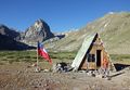
Camp & Puesto (GPT01-WP024): Base Camp Descabezado Grande. Probably the best camp spot in this area. You best take water from the spring on the right side of the river about 20 to 30 m from this waypoint. Frequently visited area. Base camp for climbing the Volcan Descabezado. Basic stone shelter occasionally used by local posteros and horseback guides.
Hot Spring (GPT01-WP025): One lukewarm pool at the Base Camp Descabezado Grande.
Water ? (GPT01-WP026): Possible access to water on the way to the summit. May be unreliable and depending on snowmelt. Please verify and report to trekking guide author.
Cross (GPT01-WP027): Cross near the summit.
Summit 3900 m (GPT01-WP028): Summit of the Descabezado Grande.
River Crossing & Camp (GPT01-WP029): Astonishing oasis in the middle of a volcanic desert. Good camp site with water, fire wood and wind protection.
Lake (GPT01-WP030): Nearly 3 km long drainless lake Laguna Caracol in the middle of pumice and lava.
Lake (GPT01-WP031): Hidden lake in volcanic crater that can be seen from the next pass.
Camp (GPT01-WP032): Camp site without fire wood and wind protection. Water is probably best taken from the spring 300 m upstream.
Water (GPT01-WP033): Clear fresh water spring.
Lake (GPT01-WP034): Hidden lake that can be seen from the next pass.
Pass 2540 m (GPT01-WP035) : Pass with impressive view.
Camp (GPT01-WP036): Probably the best camp site in this area and the only one with a meadow. Sufficient water and fire wood. The lake further down is dusty and without fire wood.
River Crossing (GPT01-WP037): Easy river crossing.
Lake (GPT01-WP038): Laguna Hornitos that is dammed up by the Crater Hornitos. You can easily ascent to the summit of the crater (60 m climb).
Trail Head (GPT01-WP039): Trail head (or end). Turn right onto the hydropower station road.
Water ? (GPT01-WP040): Possible access to water.
Gate (GPT01-WP041): Unmanned gate that may be locked. Pedestrians may pass on the right side of the gate if locked.
Gate ? (GPT01-WP042): Gate of hydropower station that was not used by trekking guide author. Please verify and report to author. You probably can leave anytime but you need a permit from the hydropower station for entering.
Bus Stop (GPT01-WP043): Unmarked bus stop on the Route 115 to Talca.
Gate (GPT01-WP044): Manned main gate of hydropower station Cipreses. You can leave anytime but you need a permit from the hydro¬power station for entering. You may ask the leaving employees for a ride to Talca.
Bus Stop (GPT01-WP045): Unmarked bus stop on the Route 115 to Talca.
Tracks
GPT01-TR001-2: Take the public gravel road from Radal to Parque Ingles. Only few vehicles use this road but traffic increases in January and February.
GPT01-TR002-1: The track starts left at the entrance of Parque Ingles. The national park trail from Radal to El Bolson is well main¬tained and clearly visible with some signposts and marks. After El Bolson the trail occasionally splits and peters out so try to follow the GPS trek when in doubt until reaching the 2560 m high pass. At the pass do not descent the well visible trail that keeps right but follow the GPS trek that descents directly towards the Laguna Mondaca. During the descent the trail is partially only vaguely visible.
GPT01-TR003-0: From the camp side (GPT01-WP016) you can cross the vast sediment field to the Laguna Mondaca.
GPT01-TR004-1: Return 1.4 km on the same trail as you arrived.
GPT01-TR005-0: Cross the pumice field and look for a suitable location to cross the smaller valley ahead. There is not trail clearly visible nor required. Keep going over the pumice and sediment field until reaching the first challenging river crossing (GPT01-WP018). The river seams to change frequently its bed so look yourself for a suitable location to cross the river and do not trust on the waypoint. Continue on the sediment field until the second crossing (GPT01-WP019). Look again for a suitable location to cross the river yourself. After the second river crossing you need to head up the ridge in front of you. The first few meters of the trail on this ridge were lost during a recent landslide. Therefore you need to find your way up to ridge and trail yourself.
GPT01-TR006-1: Follow the generally well visible trail until reaching the hot springs (GPT01-WP020). Continue on this trail until getting to the river crossing (GPT01-WP021). Do not evade the river crossing by continuing on the trail on the same side. This trail will later disappear in a steep pumice slope. Follow the mostly well visible trail on the other side until crossing the river again (GPT01-WP022). The trail now rises to the 2700 m high pass and slowly descents after the pass. The generally well visible trail will lead you eventually to the base camp of the Descabezado Grande. If you want to make a campfire you may collect some firewood in the sediment field starts about 1 km before the camp. There is little firewood at the camp.
GPT01-TR007-0-X: Several trails lead up to the summit of the Descabezado Grande. During the ascent you should generally prefer the the more solid rocky parts. During the descent the loose pumice fields allow you to slide down with less effort.
GPT01-TR008-1: A good trail heads into the 4 km wide lava river. You need to leave the main trail at the oasis in the middle of the lava flow after crossing the small river (GPT01-WP029). Get up the hillside towards your left. A vaguer trail continues through the remaining lava field to the Laguna Caracol. Pass the Laguna Caracol on the right side and follow the meandering river the feed the lake. After the spring of this river turn left and cross the wide open area. Here the trail peters out until the trail forms again at the ascent towards the pass (GPT01-WP035). Just before the pass leave the main trail and follow the GPS track towards the left.
GPT01-TR009-0: From the pass (GPT01-WP035) several vague tracks lead down. You may either look for the regular trail or follow the GPS track. The GPS track keeps on the left until it descents in a steep pumice slope towards the river. Here the GPS track joints the regular trail.
GPT01-TR010-1: The trail continues on the left side of the river until reaching the Laguna Hornitos. The trail crosses the river in a wide sediment field. Pass the lake and the crater Hornitos on the right and decent until reaching the hydropower station road in the valley far down.
GPT01-TR011-2: Follow the rarely used gravel road towards the hydropower station Cipreses. Once you reach the now unpopulated settlement you have to choose between two options.
GPT01-TR012-2: Option 1: You can take the 10 km dirt road to the regular trail section end where the next part of the Greater Patagonian Trail starts. This gets you to the more distant bus stop (GPT01-WP043).
GPT01-TR013-2-X: Option 2: Alternatively you can take the shortest way to the Route 115 if you want to return early. This gets you to the closest bus stop (GPT01-WP045). Alternatively you can wait for lift at the power station main gate (GPT01-WP044).
GPT01-TR014-4-X: Option 2: If you took the short way to the Route 115 and you still want to complete the entire trail than you need to walk 9 km on the paved Route 115. Not recommended!
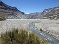
Galerry
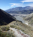
El Bolsón
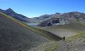
Leaving El Bolsón
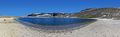
Laguna Las Ánimas
Pass 2560 m
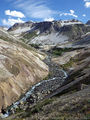
Approaching Laguna Mondaca
Laguna Mondaca
Bypasses Laguna Mondaca
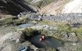
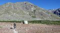
Termas de Azufre
Leaving the Base Camp Descabezado Grande
Hot springs at Base Camp Descabezado Grande


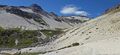
Camp near Laguna Los Hornitos
Laguna Los Hornitos
Laguna Los Hornitos


