![]()
ENG:Glaciar Nieves Negras

| |


|
|
| |||||||||||||||||||||||||||||||||||||||||||||||||||


Overview
This trek is found in the heart of the Andes. After a steep incline towards a spectacular glacier, one can basque in hot springs on the way down (or one the way too if you’re an enthusiast).


Best time to visit
- Hiking: Between February and the start of May, when the vehicular road closes for the first snowfalls. Between October and January, the River Azufre has a heavy flow and is nearly impossible to cross. For those more cautious, the best time to go is March or April, when the river is calmer.
- Randonnée: End of May or early June to September.
Access to Baños Colina
By car
From the intersection at las Vizcachas (Avenida Camilo Enríquez and Avenida Eyzaguirre, km 0), take the road G-25 towards Cajón del Maipo, and follow it until km 65.1 (asphalt ends in the km 66.3 just before Lo Valdés) where there is a bifurcation. To the left, it leads to Baños Morales along a dirt road, located on the other side of the El Volcán river. Between June and September this road might be closed if there have been recent snowstorms. You can check the road status with Carabineros at San Gabriel (+56228611008 y +56228612290) although their answers tend to be on the conservative side. This will be the last place to stock up. Continue along the main road passing the sign for Baños Morales, then 1.5 km after the fork you will pass by the mining town Lo Valdés. Six kilometres after this, passing Cuesta de los Afligidos, you will go over a bridge crossing the River Colina. 5.5 km further, by dirt road, you’ll arive at the entrance gate to the hot springs (Las Termas de Colina)- 77.1 km.
By Public Transport
Public busses to Cajón del Maipo
- Public busses (subsidized): El Alfalfal – San José de Maipo; Baños Morales (Lo Valdés) – El Volcán – San José de Maipo and El Volcán–San José de Maipo cost CLP$1200 (US$ 1.2 as of April 2024). It can cost as little as $300 for shorter distances.
- Turmaipo: From October to January first, Saturdays, Sundays and holidays. Daily in January and February. Departures at 7:30 AM and from Baños Morales at 18:000. It departures from Terminal de Metrobuses Bellavista de la Florida, platform E, or from Las Mercedes (Puente Alto) around 7:50. In San José de Maipo at about 8:35, to finally reach Baños Morales around 10:15. CLP$8000 (US$ 8.1 as of April 2024) round trip to Baños Morales, cheaper for shorter distances. Phone: +56228424208, +56222830082, +56228611518, cell +56982896718
- Buses TurMarzur: Phone +56993357800
Private vans to Cajón del Maipo
- Turismontaña: +56991219203
- Baños Morales: CLP$10000 (US$ 10.2 as of April 2024) round trip, per person, $12000 if you return a different day.
- Embalse El Yeso: CLP$10000 (US$ 10.2 as of April 2024) per person
- Turismo Arpue: CLP$10000 (US$ 10.2 as of April 2024) per person. Bookings at least 24 hours in advnace +56222117165 - +56226818475 cel: +56999320108
Both companies depart from Baquedano Metro Station (red and green lines), at the side of Telefónica building. The departure is at 7:30, to reach Baños Morales at about 10:00.
If you’re going by bus up to Baños Morales, the only option to reach Baños Colina is by hitchhiking.
Outline of the route
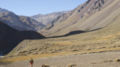
From the station located 660m to the East of Baños Colina (km 0, 2540m), follow the path that goes up the River Colina towards the hill Puntiagudo, along the North Eastern bank of the river. After 15-20 minutes from Baños Colina, you reach a bridge crossing the River Colina towards its South Eastern bank (km 0,7 - 2520m). Then, you must follow the South Eastern bank, in an area in which the valley is narrow. You will cross various little slopes, until reaching a wider zone with the ravine Estero los Caballos (km 2,1 - 2590m, ½h till this point). Immediately after this estuary, you find a meadow, often home to animals. Here, you are at the base of the hill Puntiagudo. To the side, it is possible to see a mining road. Continue towards the East through a bushy flatland. The track goes close to the cliff’s edge but remains rather clear in this part of the trek.
3.7km in (2650m), you go down a little to reach another meadow, located at the edge of the river; a pleasant place to quench your thirst. After this, finding the path is harder. The important thing is to get close: look for the closest area to the River Colina. If you get lost, simply continue going up the valley.
Note the large fossil 4.45km in in the middle of the hill.
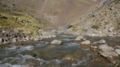
4.8km in (2680m), the path goes down to cross the River Azufre, a little further up at its joining with the river that comes from the glacier Nieves Negras, you find Estero Blanco (the meeting of these two estuaries forms the River Colina). Crossing the River Río Azufre shouldn’t be too difficult but for safety reasons you will need to take off your shoes and get your feet cold. After crossing the river there is an open field, which you must cross carefully (it is quite muddy). Once the field is behind you, the track curves to the North towards the Southern face of the volcano, San José.
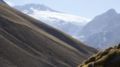
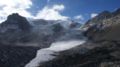
The path continues in a clear direction to the North, with the glacier Nieves Negras in the background. To the right, you will be able to see the outline of the hills Amarillo, Panamericano and Manu Tara. 7.6km in (2945m), you arrive at the estuary Blanco, that is quite fast-flowing and steep. Considering the estuary come from the valley Paso Nieves Negras.
There are many fields in the surrounding area that can get your feet damp if you’re not wearing appropriate footwear. Keep going northwards through a sloped area. In the area surrounding the glacier, the footpath disappears. It is highly recommended to continue to get a good view from what is marked as a viewpoint on the map; a pyramid shaped hill of dark rock.
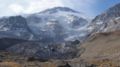
The area right before the front of the ice is very steep, loose and very exposed. Hence, ascend the east slope about 100 meters before the beginning of the ice. Then head north along higher ground, far from the steep cliff. This section is quite uncomfortable and exposed anyway.
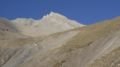
Then go down to the actual glacier and keep walking over it. There is no risk of falling into a crevasse or of dangerous slips as it is completely covered by debris. After about 20 minutes hiking over the dirty section of the glacier you will reach the aforementioned pyramid shaped hill of dark rock. At last, you will get a totally clear view of the massif. At 3220m, you will have 2500 vertical meters of ice in front of you.
Expected time
Trekking: A un ritmo normal, este trekking debiera tomar unas 3 horas y media hasta la base del glaciar (si se puede seguir la huella, de lo contrario puede llegar a ser un poco mas) y una media hora adicional hasta el mirador piramidal (dependiendo de la complejidad para remontar la morrena), sin peso y por el día. Considerar tres horas para volver.
Randonnée: Dos días y medio, pues debe añadirse un día para ir desde Lo Valdés a Baños Colinas y medio para volver. Este tramo está descrito en Lo Valdés - Termas de Colina.
Baños Colina: Access and fees
While the road is covered by snow, this route doesn’t require neither permits nor permits. However, once the road is open, normally from October to May, there is a fee of CLP$8000 (US$ 8.1 as of April 2024) per person, and $4.000 for children from 4 to 13. It’s free for children 4 or younger. The price includes right to camp and to bathe in the hot springs (payment is compulsory, whether you are interested in the hot springs or not). There is also the option to pay $30.000 per night to sleep in the hostel (per double room or double bed).
- Termas Baños Colina.
- Email ventas@termasvalledecolina.com
- Phone: +56229852609
- Cel: +56997829336
Recomendaciones
- La mejor modalidad para este trekking es partir un viernes en la tarde a dormir en las termas (cerca de dos horas y media desde Santiago) y relajar los músculos en los pozones con vista a Los Andes nocturnos. Se debe tener en cuenta que Baños Colina es AMPLIAMENTE visitado, normalmente hay MUCHA gente. Luego partir el sábado temprano, volver a bañarse a las termas y volver a Santiago el mismo día. Por supuesto es posible también partir un sábado, pero en ese caso los pozones posiblemente estén mucho más llenos.
- Hay agua a lo largo de todo el camino, por lo que no es necesario cargar mucha.
- El cruce del río Azufre puede ser delicado en la época de deshielo (noviembre a principios de enero), pero no debiera ser un impedimento para personas sin aversión especial a este tipo de cruces.
- El río Colina, que se cruza a pocos minutos de andar por un puente amplio trae mucha agua, pero NO se vuelve a cruzar a pie, el río que se cruza es el río Azufre, mucho más pequeño.
Enlaces externos
Galería de fotos
Vista desde el cruce de río (24 de Mayo 2014)
Vista frontal del cajón, al fondo el glaciar (24 de Mayo 2014)
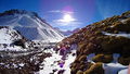
Vista hacia el Cerro Puntiagudo. Julio de 2013. Imagen: Sebastián Divin Larraín
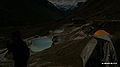
Baños Colina. 8-5-2009.
Cerro Puntiagudo. 9-5-2009.
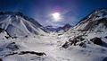
Valle del río Colina. 9-5-2009.
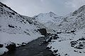
Estero Los Caballos. 9-5-2009.
Cumbre Volcán San José. 9-5-2009.
Glaciar Nieves Negras. 9-5-2009.
Glaciar desde su base. 9-5-2009.


