![]()
ENG:Volcán Láscar

| |


|
|
|
| |||||||||||||||||||||||||||||||||||||||||||||||||||||||||||||||||||||


Overview
Láscar is the most popular climb in the San Pedro de Atacama area, and for good reason. The ascent is brief, and the view over the crater is spectacular, as it’s the most active volcano in the region. It’s a giant void in the Earth, spiced up with strong sulphurous gases.
Best time to go

Possible year round, although during January and February checking the weather forecast is a must. There could be rain and snow associated to the “Bolivian winter”. The Andes at this latitude are dry, but not as dry as the coastal cities. Said that, the precipitations rarely are significant enough to restrict an ascent, can offer a more beautiful landscape, and avoid the need of carrying all the water. In winter (June – August) the weather is extremely stable, always sunny, but the night temperature is very low. Best months are during spring (September to early December), with stable meteorological conditions and more moderate temperatures during the night
Access
By car
.JPG)
.JPG)
.JPG)
.JPG)
From San Pedro de Atacama, drive southwards along the paved route 23. After 48 kms, past Toconao, there is a right turn to Talabre. After Talabre Nuevo, the last inhabited place, the pavement ends. Then you will pass by Talabre Viejo, of which only ruins remain. Keep on driving along this dirt road, at times plagued by very uncomfortable bumps. Láscar appears soon in front of us, but the road takes a long detour to the south. Just before arriving to Lejía lagoon the road must be left in order to take a bifurcation to the left. Here the off-road stretch begins (yellow track in the map). This point is located 97.4 kms from San Pedro de Atacama. The first section is easy: very flat and compact ground. There are numerous tracks that can be followed, all braided in a rich net. You can choose any of them. Once at the foot of the mountain, the inclination increases significantly. The road becomes trickier and a reduction gearbox may be needed. At 4946 there is a very steep and loose stretch. Only high and powerful vehicles can handle that (waypoint "zanja difícil"). If it’s not possible to overcome after a try or two, it’s better to give up, as the absolute end of the road lays at 4981m. Consider three hours of driving from San Pedro de Atacama.
By public transport
Needless to say, there is no public transport to this remote corner of the highland. It’s also very difficult to hitchhike, as almost all the vehicles that get to this point belong to tourist agencies and hence are not allowed to give a ride. Neither is possible to hire a taxi in San Pedro de Atacama, because the road requires a 4x4. The only real option is to rent a pick up in Calama.
Outline of the route
From the beginning (km 0 - 4981m) the route is pretty obvious. A heavy trodden trail advances northward, pointing to the saddle that connects the east and west summits. At first it goes straight, and then, as the inclination increases, on a zigzag. Impossible to get lost. After about 1.2 kms, at 5354m (although there is no precise point for this) a choice must be made: either go on along the clear trail or take the shortcut to the summit, walking along a scree on a pathless slope. Following the road is much more comfortable, due to a firmer ground and less inclination, and allows you see the active crater from a short distance, but it’s much longer. Wikiexplora’s advise is to take the trail on the way up, and the shortcut on the way down. Once in the saddle you will stand in a huge cliff, originated by the spectacular crater. If you see tours in this area you will notice that they take their tourists to the lower east summit, as it is only a couple of meters shorter than the west summit. From the saddle border the crater to the west. This stretch can be very windy. Curiously, despite how popular Láscar is, the trail starts to vanish little by little, proof that very few who visit this volcano go to the real summit. The walk turns progressively to the southwest. Once on the top of this slope, still on the rim of the crater, don’t let your illusions get loose: the summit is still quite far to the southwest. You will still have to walk 1070 meters and go down 82 meters to the plain that precedes it. Having gone down to the plain cross it and face the last leg on the right, where there is less inclination (the left side is too rocky and steep). Once in the summit there is a magnificent view of Volcán Aguas Calientes and Volcán Pili.
Expected time
For those already acclimatized, consider threes hour and fifteen minutes, and only one hour and a half on the way back. To the east summit, allow about two and a half hours.
Permits / Rates
 |
This route is free and permission is not required |
|---|
Guides (optional)
Being one of the most popular option for the tour operators in San Pedro de Atacama, the offer is ample. They normally leave San Pedro de Atacama at about 6:00 AM
- San Pedro de Atacama from CLP$90000 (US$ 95.3 as of July 2024) per person by small parties to CLP$60000 (US$ 63.6 as of July 2024) for groups of ten people.
- Vulcano expediciones
- Address: Caracoles 317, San Pedro de Atacama
- Phone: +56552851023
- Volcano Aventura
- Address: Av. Calama 419, San Pedro de Atacama, Chile
- contacto@volcanoaventura.cl
- reservas@volcanoaventura.cl
- Phone: +56979885697
Recommendations
- There is no water in the whole route
- Do not attempt this mountain unless you have spent several days at some altitude, as the altitude gain, considering the drive, is extremely fast.
Photo gallery
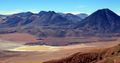
Lejía lagoon from Volcán Láscar. November 2016
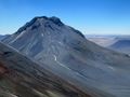
Volcán Aguas Calientes from Volcán Láscar. Looking east, November 2016
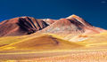
On the way to Lejía lagoon and start of the ascent of Láscar, from Talabre
.JPG)
.JPG)
