![]()
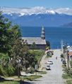
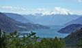
GPT22 (Cochamo)
Add a new log entry always on top in the appropriate season sub-chapter and use format:
* Start Date to Finish Date (use Format YYYY-MMM-DD) / Duration in Days / Hiking or Packrafting / Travel Direction (SOBO for Southbound or NOBO Northbound) / Chosen Route and/or Option Name (RR for Regular Route) / Names or Alias
Summary with remarks to route that are considered useful for other hikers and packrafters. Include alerts, suggestions and personal perception of attractiveness and difficulties.
Add a sub-chapter by placing two "=" before and after the new sub-chapter heading ('==Sub-Chapter Heading==').
Contenido
Section Log, Alerts and Suggestions
Season 2025/26
Season 2024/25
Season 2023/24
2024-01-07 to 2024-01-14: Fangwen and Tobi / 2.5 days Ventisquero Valley (Option 08 + more), 4 days El Manso to Cochamo RR / NOBO hiking.
We did two parts along this enjoyable section, connecting them by hitchhiking and resupplying in between in Llanada Grande.
The first part was hiking ~20km into the scenic Ventisquero valley (Option 08), alongside a wonderful river on an enjoyable and easy hiking trail through farms and rainforest that mostly follows an old minor road. It's often better to follow the well-marked trail rather than the GPT track files. A highlight of our trip was hiking up to a fantastic viewpoint at 1100m with a view of the whole valley, its remote side valleys and glaciated mountain peaks. The trail (900m elevation gain, 4.5km) through the thick rainforest is steep but excellent in quality and easy to follow (but the turnoff at S 42° 01.737', W 072° 05.643' is easy to miss). This and other trails in the valley are not part of the GPT files yet, but GPX files can be found on the website of Rincon Bonito (glamping accommodation for groups) that presumably created the trail. We camped by the viewpoint; what a wonderful experience! There are plenty of places to pitch up a tent, but little protection from wind. We found a wind protected camp in a dried-out puddle at (S 42° 02.705', W 072° 06.193'). Make sure to bring water, since the last reliable water source is in the valley, just before the turnoff onto the steep trail. From the viewpoint, we attempted to climb the local mountain, but beyond 1500m, it appears to require bush bashing. Our track: Media:GPT 22 Ventisquero Viewpoint.gpx. The viewpoint is within the Pumalin National Park, but the whole valley seems to be private property and camping is forbidden outside official campsites, which begin quite far into the valley. There are plenty of spots to pitch up a tent nonetheless (which is what we did). For packrafters, going down the river must surely be a highlight! Rincon Bonito offers packrafting (maybe only for their guests?), they describe it as class II+.
Our second part followed the regular route 22N from El Manso to the Cochamo trailhead. This was an enjoyable hike and we found the trail to be in good condition, although it gets pretty muddy around El Arco (and that's after one week of sunny weather). There is quite a bit of pointless up and down between km45 and km79. Additionally, our hiking distance was often 20-25% longer than expected, as there are many switchbacks too small to be represented on the track files. We liked hiking this section northbound, as the rainforest and the views get more and more impressive as you go along. La Junta has a lot of local hiking options (e.g. hiking into the Anfiteatro valley or on top of Cerro Trinidad), but we didn't spend any extra days because the weather was turning.
Logistics: to get to the start of section 22, take the daily bus that leaves at 7.45am from Puerto Montt (stops at 8.15 in Puerto Varas at intersection el Salvador/San Pedro S 41° 19.081', W 072° 59.038', and later in Cochamo). The bus company Río Puelo has a ticket office in Puerto Montt, their WhatsApp number is +56 9 7408 9199. From there, take the ferry across Lago Tagua Tagua and the connecting bus down the valley to your respective trailhead (El Manso for the Cochamo valley, Primer Corral for the Ventisquiero valley). Note that travel is slow... We arrived at the Primer Corral at 4pm. We left a bag of food for the second half of our trip. Unfortunately it was visible from the parking lot and got stolen, so we resupplied at the Llanada Grande supermarket. The bus makes a stop there for ~15min, if you want a quick resupply there (it's a bit bigger than in El Manso). We hitchhiked to El Manso, which worked after two hours of waiting/walking (not a lot of traffic).
If you are in the Llanada Grande area, go to Camping Reflejo Azul. The campsite itself is average, but it has the most beautiful river we have ever seen in our lives. Visit this truly special place before Instagram influencers find out about it and it becomes overrun by hordes of tourists. Day access is possible also for 5.000 CLP.
- 2023 Dec OH-TL-V / Anh
Note: the trail OH-TL-V alias Cerro Arco Iris was damaged by big rocks in the last season and is completely closed. A new route or repair is not in planning.
- 2023-12-17 to 2023-12-21 / 5 days / Hiking + Packrafting / SOBO /RR & Option 01B / Roman
Route: Hiking from Cochamó to El Manso. Bus to Lago de Las Rocas. Packrafted the lake and Lago Inferior. Hiked to Lago Puelo.
Due to the border crossing, there is a thread about it on Facebook: https://www.facebook.com/groups/222224388283455/permalink/1709504102888802/. I applied online - no answer. Went to the carabineros in Cochamó they couldn't issue it, so I went without it (it worked without a problem)
Started in Cochamó (there is a bus to the entry I just got him by hitchhiking so I don't know the schedule) and had a reservation for Camp Trawen (Fruit, Groceries, Electricity). This is getting checked at the entrance if you have one. The trail to the camp was a bit muddy (2 days of rain before the start) but all doable. The next day went to the northern end of Lago Vidal Gormaz and slept there at Lake {22-05} [7.9/604]. Bridge destroyed at: -41.43696, -71.96632 and Bridge {22N} [63.0/337] (Rio El Colorado). Both are crossable dry feed due to trees. Generally, there is no fording necessary after Lago Vidal Gormaz. Before yes. Packrafted Rio Manso. There were no rapids on the map, it's mentioned in the Manuel that it can be challenging. There are some rapids but all are doable and manageable (I am a beginner with kayak experience and an open deck packraft). You can get easy access to the river at -41.692561, -71.972725 this is 300m after the mark in the file. There is a dry river bed to avoid BB to get to the River. The river is fast flowing. Follow the GPS only at one point where the river splits pay extra attention: turn left as shownin the GPS: -41.698615, -71.985482 . Went out at the south side of the bride: Bridge {22N} [40.8+0.2/36] (Rio Manso) on the right side. There is a trail to the street with one gate where you can walk through on the right side. The shop Settlement, Shop, Bus {22N} [40.7/36] (El Manso) has good supplies and free WiFi. The trail to this point is very good. Based on previous comments and a chat to a local I want to skip at least to Puerto Urrutia [comment in: 2023-FEB-01 to 2023-FEB-07]. There is an official bus going all the way from Rampa Punta Maldonado -> Segundo Corral. Find the schedule here: https://imgur.com/a/7MVEscb . The shop owner said the bus is normally there at 02:00 PM. The bus was there in my case at 02:30 PM. This bus stops at the large supermarket [Supermercado Llanada Grande] a great place for a last resupply). The bus also stops at Puerto Urrutia but I went all the way to Lago de Las Rocas and used OH-MR-V {22-01B} [8.2+1.9] to get to the lake. Started packrafting at 05:00 PM. The start was fine. The wind got worse during the evening and was to my capabilities on the maximum with serious waves. Strong wind from the north. It was pleasantly paddling after going through the gap at -42.069608, -71.813735. Camped at Lake, Camp {22S} [21.8/314]. Got there at 07:45 PM. Crossed the border without any problems. Packrafted Lago Inferior and got in the water here: Lake {22S} [20.9/201] at 10:00 AM. The wind got stronger but manageable. Exited the lake at 11:15 AM at -42.102244, -71.742575. The trail back to the RR is good to hike. From there, the trail is in good condition. Due to the higher water in Rio Azul fording and therefore the RR is not possible. You get also the recommendation from the Argentinien carabineros to take Option 03. I didn't want to take this and followed the RR to this point: -42.091481, -71.633667. From there I followed the trail to this point: -42.09399, -71.634188. There is an old dock [image here: https://imgur.com/a/5LMsKA1]to put in you packraft. The trail can be downloaded at the end of the comment. There I packrafted with very strong onshore wind and if it hadn't been for only 300m I wouldn't have done it to (03:15 PM):-42.096114, -71.628682 ,and walked from there to the end of GPT22.
Overall: great section! It's a nice trail to hike and packrafting rRioEl Manso is a lot of fun and a great change in perspective after hiking for a few days. After that, the trail continues bto bein a good condition. The conditions for Lago de Las Rocas should be closely checked. I would definitely recommend it!
Trail download: https://1drv.ms/u/s!AqzLweJ3NZW5q7YZzDoW3qlKypqwBg
Contact: https://linktr.ee/RundW
Season 2022/23
- General advice : The Regular Route is best hiked between December and April. The primary obstacles are high river levels early in the season and after rain. During the peak period of January and February it may be difficult to obtain a camping reservation at La Junta which could prevent a southbound traverse.
- 2023-Feb-18 to 2023-Feb-23 / 6 days / Hiking / SOBO / RR + 22-01 / Martin & Helena
A lot has been already written, so just a few comments from our side:
No problem with entering the valley in SOBO direction, until the noon aprox., saying you will spend the night at the refugio El Arco - they have some time estimate for this hike and can’t let you in if its late. By the entrance you can buy some useful things that might be hard to buy in Cochamo, like gas or peanut butter. There was also a beer truck with quite good wifi connection (only during summer). Crowds of people in both directions, quite muddy trail. Detour to the Toboganes is definitely worth it. We spend the night after all in a marked camp aprox. 4 kms before the refugio and it was a good decision - there were quite a lot of people when we passed by the next day.
From the refugio its nice and easy walking. We spent the night on the southern side of Lago Vidal Gomaz where is amazing campsite Doña Luisa, for I think 5000 CLP pp. We bought there beer, some cheese and bread in the morning, and you can also charge electronics inside. It is possible to have proper breakfast or dinner, it looked all very tasty. At km N 40.7 is shop with all the basic things + great brewery next to it, definitely stop there if you are a fan.
Based on other comments and our time schedule we decided to take the alternative 22-01 to Llanada Grande. This is a good resuppy spot as there is a new and big (at least in comparison to what you would expect in a place like this) supermarket that replaced the old one destroyed by fire. Good place to stay is a campsite at the end of the village, on the right side, run by really nice lady. Not expensive and if its free, you can stay for the same price in a so called refugio, that is actually just a very small room, but for us better than a tent. Hot water and electricity + possibility to buy pizza and maybe some other small things - there is actually no restaurant in the village. Some more road walking around Lago Totoral to Rio Puelo to connect back to RR. In general not very attractive part of the trail. Great restaurant in Hostal Puelo Libre with local beer and view on the river.
From the port its again easy walking on the RR again. Drunk settler and quite agressive dogs out of his control at S km 7.2 so be careful. We slept half way to Las Rocas lake. We thought about taking the RR around the lake, but the landslide caused by snow (aprox. 1.5 km from the port) looked quite difficult to pass. We discovered there is possibility to cross the lake on one of the locals boat, which we did in the end. We were lucky that after waiting for some time in the port a car with locals arrived. Happily for us they arranged a boat transfer with other residents to get to the other side of the lake, where they went for a lunch. We were able to go with them, and after picking up their friends, we all hop off the boat close to the police station. Great experience and we learned a lot about this area and people living here. We paid 10k CLP. In the comments here is a contact for the guy with a boat, but without signal it must be arranged in advance, and the price might differ when not sharing the transfer with others. No problem with the border check. It took us around 4 hrs to get to the argentinian side, where everyone was super friendly as well. They offered us to camp there, but we decided to make it to Lago Puelo, which took us 2 more hrs. The landscape changes significantly on the other side where everything is more dry. No problem with the river crossing. We got off the trail directly on the main road.
Contact: @martin_hanzelka @helenneka
- 2023-FEB-01 to 2023-FEB-07 / 7 days / hiking / SOBO / Cochamó - Lago Puelo / Anna & Christopher
We hitchhiked from Eco Camping El Valle to the entry of the park and arrived around 8 am. We told them that we would camp at the Refugio El Arco and explained our further route. Until la Junta there were lots of chilenean tourists, therefore the path was very good only with some muddy stretches. Like Véronica we walked to Toboganes, a waterfall/stream with beautiful rock formations. There were tons of people, but it's worth it. La junta seems to be an amazing place for rock climbing, we would have loved to have some climbing gear with us.
After la Junta there were almost no more hikers. We camped next to the Refugio, as there were already two other groups of hikers sleeping in the Refugio.
Until Lago grande there are still some muddy stretches and blowdowns, but generally it is a good path. From there on the path is perfectly maintained. We camped at approx. km 66 next to Río los Morros.
Nice path until El Manso. We resupplied at the minimercado and camped next to the river, which was a beautiful camping spot with lots of delicious blackberrys.
The next morning we arrived at Señora Ocos house around 8 am. She contacted multiple people and luckily found out that there was somebody crossing the river to our side at 11 am. The man, whose name we unfortunately forgot, was super friendly and dropped us off after the river mouth of Rio Traidor, close to where he lives. He charged 10.000 CLP p.p.
The path to the first settler was mediocre and afterwards got worse and worse until it was almost pure buschwhacking. It was the worst we had so far on the GPT. Thorns.. Lots of thorns tearing away at your clothes, backpack and skin. We camped at the river at approx. km 12, which was a beautiful spot. Until the settlement Las Nieves the path continued beeing bad with lots of bush bashing. The settler told us that no locals use that path and she also told us that there are no regular boat transfers to Puerto Urrutia on weekends (it was sunday..). We wouldn't do that stretch next to Rio Puelo again and instead hitchhike from El Manso to Puerto Urrutia.
At the boat transfer waypoint to Puerto Urrutia we had Entel service and contacted one lodging on the other side. They told us to go to the last house 1km back to ask for a transfer (it's the house of the man who does the boat transfer on weekdays). But we got lucky and a boat passed by and took us to the other side. The man on the boat also told us that the path from Río Traidor to Puerto Urrutia "is closed".
We continued to Lago verde, where we planned to camp, but it's surrounded by dense forest, apart from a private property. That spot is amazing, a little landing stage to go swimming, a great view and a very friendly owner. She even baked some delicious apple bread for us. For camping she charged us 8000 CLP p.p.. That was definetly worth it.
After Lago verde there is a minimarket. We didn't check it out, but there is no resupply wp yet.
After reading previous blogs and having had enough of thorns we decided to cross el Lago de Las Rocas by boat. Therefore there is a walkie talkie on the landing stage on the northern end of the lake with which you can contact Richard. We also got his number (+56958694897), if you want to contact him in advance. When we arrived at the lake, there were already lots of people waiting for the boat so we just waited with them and after some time got knocked the boat with them. The ride was really nice across the crystal clear blue water and we were charged 5000 p.p.
From the southern end of the lake it's just a couple of minutes to walk to the chilenian border control. We continued on and camped at km 30 at the river. Again a really beautiful spot.
The next day we passed the argentinian border control and continued to Lago Puelo.
The section was really beautiful, except the part with the thorns. There are lots of streams along the whole trail, so one does not need to carry much water.
- 2023-Jan-29 to 2023-Feb-02 / 5 days / hiking / NOBO / RR mostly / Frank
I got the bus-ferry-bus from Puerto Montt to Segundo Corral. To avoid the landslide at Laguna Las Rocas & delays with the river ferries I walked on the road from Segundo Corral to El Manso, about 50KM. Easy but not very interesting walking. It takes a full day to get from Puerto Montt on the bus to Segundo Corral so I believe it would be better to go SOBO with an early start to get through La Junta, otherwise you need 2 additional days for travel.
Stayed @ nice & cheap campsite at bridge over Rio Colorado & camped at El Arco. The trail approaching El Arco was muddy & a bit swampy (it had been raining). It's possible to go by boat across Lago Vidal Gomez but it's an easy 3 hour walk.
Got the bus again to Segundo Corral & ferry to Paso Bolson. The trail across the border is generally in good condition. There is some easy bushbashing on the Chilean side for about 1KM before the border & some fallen trees but they are straightforward to go over. Rio Azul was easily fordable in early February.
- 2023-Jan-10 to 2023-Jan-14 / 5 days / hiking / SOBO / RR, also GPT22-01 / Véronica
Route: Cochamó - La Junta - Lago Vidal Gormáz - El Manso - Puerto Urrutio via Option 1 - Lago Las Rocas - Lago Puelo (Argentina)
The borders of Paso El León and Paso El Bolsón are both opened again for tourists! Go for it! It is a beautiful section with wonderful people, such a contrast to where I started the GPT further north.
In Cochamó, I stayed at Eco Camping El Valle, right at the entrance to the Cochamó River Valley. Paid 7000 clp, very nice campground, there are tarps over the picnic tables at each site so you have a dry place to hang out even if it rains :) Since I spent the night so close to the trailhead, it was easy to get to the guarded valley entrance (Road End {22N} [109.8/58]) early. I did not have a camping reservation for La Junta. I arrived at the trailhead at 7:30 a.m., explained my route to the staff, saying I would stay at Refugio El Arco that night. They let me through no problem. The trail to La Junta is a bit muddy, but nothing bad, my feet stayed dry in my trailrunners despite the fact it was also raining off and on. Beautiful path through the Valvidian rainforest, I really enjoyed all the green and the moss. When I reached the La Junta area, I stashed my pack in some trees and made a short detour to Las Toboganes. They are only 0.7 km off the regular route, and highly worthwhile to see! What a spectacular area, I totally see the Yosemite resemblence, and would love to go back someday.
I found the trail after La Junta (all the way to Lago Vidal Gormáz) to be in good shape, contrary to what others have written. It was maybe slightly less maintained than the popular trail leading into the valley, but it was still very clear and easy to follow — not overgrown, no blowdowns, just a bit muddy in some places. Granted, it has been drier than normal so far this summer. None of the fords went above my knees, and sometimes I could cross the creeks without even getting my feet wet, all very easy.
The refugio at El Arco is dark and without any furniture inside. I found it much nicer to camp in the nearby meadow just south of the trail there. There are outhouses.
Nice path from Lago Vidal Gormáz all the way to El Manso. Very beautiful in this valley as well. Met a few arrieros along the way. Most of the rivers have bridges crossing them. There is a small camp at the bridge over Río Colorado.
In El Manso, I topped off my food supply at the shop on the main road. It has a good selection of food items. Then I went to Señora Oco's house to try and arrange a boat transfer over Río Puelo. She and her family are very friendly and welcoming. I arrived there mid-afternoon, but she could not get in radio contact with anyone on the other side. In the evening, we heard back from Hospedaje Nancy, who charged 60,000 clp for a crossing upriver all the way to Río Traidor (where she lives). This I found too expensive for me traveling alone. Señora Oco baked some bread and I was able to buy some. She also said I was welcome to camp in the fields behind her house while waiting for a response from settlers Paulina and Jovino regarding a crossing to their place (much more direct and therefore likely much cheaper). The next morning, we still hadn't received any response from Paulina and Jovino either via radio or Whatsapp (they may have been away). Because of this, I decided to take the gravel road to Puerto Urrutia (Option 1), and forgo crossing Río Puelo, unfortunately. Despite this setback, I'm really glad I got to meet and spend time with Señora Oco and her family, they are such kind people.
I was able to hitch most of the way to Puerto Urrutia, where I rejoined the regular route. The trail from there all the way to Lago Las Rocas is mostly easy and clear. There were a few confusing junctions in the vicinity of Lago Verde, so I kept a close eye on the GPS there. After crossing the road after that, the beginning of RR -TL-V {22S} [2.8/7.1+2.7] is tricky to find. There are lots of fallen trees and many forest paths. The GPS was very helpful there too until I finally found the right path. After about 700 m it merges with a nice clear path all the way to Lago Las Rocas.
As has been previously reported, there is a large rockslide about 2 km in once you reach Lago Las Rocas. It didn't look overly dangerous to me, the boulders were large and seemed solid enough. I started crossing it right at the bottom where the rocks fall into the lake, as it looked to be the easiest and safest way across. I was maybe 50 meters through it, when a boat came along, and the people in it told me to hop in! What lucky timing! As we passed the rest of the rockslide, I could see the last part of it was steep, loose scree rather than big boulders. That part would have definitely been nerve-wracking to cross, and I was very grateful for the boat ride. The settlers who owned the boat live about 3 km along the trail, at a little bay/inlet in the lake. They have a nice beach and campground too. That's where I rejoined the trail. Beyond their house, the "Camino Los Mosquitos," as it is locally called, gets progressively worse in terms of overgrowth and blowdowns. The trail has not been cleared since the past winter, and not been used either. The stretch between kilometers 4 and 6.5 is the worst. It felt more like pure bushwhacking than following a trail. The path was mostly burried beneath walls of downed trees and branches, it got very hard to follow at times. Lots of climbing over and under vegetation, some of it quite thorny too. Very slow and tiring. My pack got ripped up a bit and so did my clothing. Had I known the trail was this bad, I would have taken the option on the east side of Lago Las Rocas. It's hard to imagine it could be in worse shape than the regular route.
When I got to the Chilean Border Control it was around 6:30 p.m., so too late to cross that day. The border agent working there was very friendly, but he couldn't get in contact with his supervisor to get approval for stamping my passport with the next day's date. So I camped back at Lago Las Rocas, and the next morning came back at 8 a.m. when the border post reopened. The trail on the Chilean side of the border was a bit rough in places, it has been neglected since the winter too. But it was not as bad as the previous stretch along Lago Las Rocas. Once I got into Argentina, it got much better. The trails in Parque Nacional Lago Puelo are well-maintained, and I met some day hikers. No issues at the Argentine Border Control.
I was able to ford Río Azul easily, thanks to the dry weather. There are three branches of the river to cross (the GPS waypoints only show two of them). The middle branch is the widest and deepest. The water there went up to my upper thighs (I'm 165 cm), but the current was slow and it never felt dangerous.
Now I'm skipping down to GPT32 to continue my adventure further south :) The northern sections that I hiked from 6 to 22 were simply amazing, with great weather almost the entire time. Thank you, all!
- 2022-Oct-19 to 2022-Oct-24 / 6 days / hiking / SOBO / RR / ???
Here are the main points because our story is long :) Paso el bolson and El Leon are closed for tourists until further notice Some of trails are in bad condition because of the hard winter but they might be cleared in the following weeks. Landslide in Lago Las rocas - very dangerous part to cross. We suggest to take an optional route
The trail starts in valle cochamo. We did not have any reservations but as we were in low season we were not worried. However the lady from the tourist office in Cochamo told us to arrive at the entrance of the valley between 7 & 8 to avoid being rejected. At 7h50 there was nobody at the reception so we did not have any trouble, but we cannot say for the high season. You can arrange a car transfer to go the valley entrance. The numbers of the drivers are available at the tourist office.
The trail until La Junta is muddy but well maintained - no worries there. Up there we met some arrieros and the locals from the camping and they told us that the trail was closed a bit further because of snow (up to 2 meters) in laguna Blanca. This is the highest part of the trail (about 1100m). The river crossings were feasible, but as they forecasted rain for the next day, we preferred to turn back in order to avoid being blocked between high rivers and snow.
Back on the road between Cochamo and Puelo, we caught at about 10:30 the bus that leaves at 7:45 from Puerto Montt, to go to Rio Manso. There is a well furnished Shop where you can even find gas. We remained in the Southbound direction and went to Senora Oco's house. She was very welcoming, and her and her grandchild helped us in arranging a boat transfer for the following morning (nothing was possible the same day). We paid 50000 pesos to go from their house to Rio Traidor - close to Nancy hospedaje. Indeed, we skipped the first part of the trail as they told us that it was very closed with a lot of small trees and not used anymore. Maybe it would be cheaper to cross a bit south using the cable car or directly from Manso to Rio Traidor.
Until the Rio Tigre, settler # 22N [7.7/157], the trail is visible but sometimes with some obstacles (fallen trees). After this settling, you will have to cross the Rio Tigre which might be the hardest to cross on your way if you have a lot of rain. There is a bridge indicated on the tracks but it has been swept away this winter. The best place to cross is a bit higher following the river, follow the horse track. We did not have any problem crossing, and probably the settler could help you with his horse if the river is too high. That is an advantage of the Southbound direction.
After, the trail is really clear. We found the last transfer across Rio Puelo about 1 km before the point indicated on the track. It is his job to do the crossings and he also does sportive fishing if you are interested. Look for a house with a border collie with a piece of wood around the neck :)
From Puerto Urrutia, the trail is clear again until the road. There is a shop at 600m on the right. Again here, the trail is closed due to fallen trees at the beginning, but the locals (last house on the right) will help you find another path. Clear trail until Lago Las Rocas.
Once you reach the Lago Las rocas you will be blocked after 2km. Indeed there was a landslide this winter and you have to cross a very dangerous part of about 300 m of rocky mountain slide. It is not stabilized yet. We went through but we do not advise it. Also, there were a lot of fallen trees and the path was really tiring. The locals will probably clear the path in the following weeks. To get more information we suggest to contact the camping Playa Las Rocas on Instagram. You can also consider the other routes or arrange a boat crossing.
Finally we arrived at the border crossing. Unfortunately it was closed due to the Covid, except for the very locals (people from Cochamo). Apparently Paso el Leon is closed as well for tourists. Be aware of that if you have to cross the Chilean- Argentinian borders, as small passes seem to be closed for tourists. In the end we had to go back to Puerto Montt crossing the Lago inferior with a free boat (ask the carabineros), and then the bus-ferry-bus from Segundo Corral.
Season 2021/22
- 2021-Nov-23 & 2021-Nov-25 / 2 days / Packrafting / SOBO / Estuario de Reloncavi from Ralun to Rio Puelo (Western shore) / Jan Dudeck & Meylin Ubilla
We paddled in two easy days the roughly 40 km southbound.
Start at Ralun at Puente Petrohue: On the right side of the bridge (view in river flow direction) is a suitable put-in and good spot to camp. The gate was closed but not locked. There are signs of people occasionally camping there.
Ralun to Cochamo: Packrafters in need to resupply can do this in Cochamo about 16 water kilometers from the put-in. Both, the western and eastern coast are suitable for packrafting. The eastern side is next to the main road what facilitates switching to hiking. The western side is less intervened and more scenic.
Ralun to Rio Puelo: Again, the western and eastern coast are suitable for packrafting. The eastern side is next to the main road what facilitates switching to hiking but requires the crossing of a 4 km wide bay in open water. The western side is less intervened and more scenic but requires crossing the 3 km wide Estuario de Reloncavi near Rio Puelo. On the western side are also the Termas de Sotomo that are suitable for camping.
Wind: On nice sunny days “viento sur” often kicks in around 10 am making southbound paddling difficult or unfeasible. We had two partially overcasted days and could paddle on the first day till 4 pm when wind became annoying strong. On the second day around 3 pm the wind and waves became unpleasant but by this time we were walking the final kilometers into Rio Puelo.
GPT22: Southbound packrafters may take in Cochamo or Rio Puelo the bus to Lago TaguaTagua an get to the recommended packrafting starting point of section GPT22 halfway into this section to Flip-Flop as recommended.
- 2021-NOV-18 / 1 day / hiking / NOBO / Cochamó Valley (Lago Tagua Tagua - Lago Grande) / Tobías
The Section between La Junta Base and Lago Vidal Gormez was very challenging. It had been raining a lot, so the Trail was very muddy and I had to cross several rivers and creeks. Went straight from Cochamó to Lago Grande and camped there in some Snow. Met only a few settlers. After reaching Lago Vidal Gormez, the Trail was easy and I enjoyed the hike a lot. Amaizing área up there!
Season 2020/21
Season 2019/20
- 2020-FEB-18 to 2020-FEB-21 / 4 days / Hiking / SOBO / RR / Tyler
I didn’t have problems getting a campsite at la junta on the spot luckily. AMAZING area that I’ll be returning to again to do all the day hikes in. Aside from that, most the trail was very muddy, rainy, and unmaintained. This got a bit difficult after the 3rd day in a row. Good places to camp at the lakes over the pass SOBO. When I got down to Lago Vidal Gomez the trail improved.. I got some bread from a settler at the start of the lake. There right on the trail and super friendly and have rooms. The last ferry across Tagua Tagua leaves at 7 pm. I didn’t make it, so I slept underneath the office/bathrooms and took the ferry at 8:00 the next morning. I believe there’s another ferry at 12.
- . 2020-Jan-09 to 2020-Jan-11 / hiking / SOBO / RR / Shaun
Despite the austere warnings on the La Junta Camping website, I was able to make a reservation at short notice in high season, and the back and forth process only took a few hours. In Cochamó, I was warned that due to recent rain the river crossings at El Arco and another nearby river would likely be impassable. With four more days of heavy rain forecast, I decided to take the bus-ferry-bus combo to Puerto Urrutia and try to walk northbound from there with the optimistic hope that by the time I reached El Arco the river would be passable or, at least, the wait would be less. However, 10km north of the Rio Puelo crossing (service starts at 9am) my way was blocked by a high and fast river. I then retraced my steps and completed the rest of the section southbound - which was straightforward. The trail on the west side of Lago de la Roca until the frontera is a bit overgrown but still easy to see and nothing particularly slowed me down. On the Argentinian side the trail is well maintained. It is not permitted to camp on the 12km stretch between the border posts. I arrived too late to cross that day, but the Chileans stamped my passport with the next day’s date so I didn’t have to wait for the post to open at 9am. The Argentinian border guards informed me that because of the rain, the Rio Azul was too high to ford at the point on the regular hiking route just before Lago Puelo so I took the alternative route (Oh-Tl-V@22-04-#001) a few kms north and crossed over the La Pasarela bridge.
- 2020-Jan-22 to 2020-Jan-26 / 5 days / hiking / SOBO / parque de la vallee de Cochamo - La Pasarella / Arnaud
As we arrived from Puerto Montt we were with the bus and stopped directly at the entrance of the private parque de la vallee de Cochamo. As it is private, there are some rules to get in, or they block you at the control point. The entrance is free but you need to have a reservation in one of the official camp sites there. To get the reservation, you can do it on internet (but you need to wait for the confirmation and it can be several days long), or do it directly there (red house), they give you the reservation voucher if there are places available (number seem to be limited). Then you pay the night when you reach the camp sites (6000 clp/pers). Or the other solution is to say that you sleep in the refugio del Arco. It is 23km further after the control. Then it is free and no reservation is needed, but this is possible only before 10am (after they block you). After 10am the only way to pass is to sleep in the camp sites. They block you if you do not have a reservation voucher for one camp site. This spot (la Junta) is famous among the chilenos so the access to the camp sites is really overrunned. The path is easy to walk. Once you go further than the campsites, you're alone, so it is better. The path is clearly marked. There are bridges for most of the rivers you cross. But it is very muddy. At the lago Vidal you can resupply a bit with those living there (you can also sleep in their camp sites). In El Manso you can find a minimarket with lots of things. Then, we decided to follow the road instead of the track because we were in a hurry with a deadline in El Bolson, until we reached la cruce de la rocas. There are buses or hitchiking is easy. Crossing borders was easy. There are 12km between the chilean stamp and the Argentin one that we did in 3.5 hours. At the very end we have not not crossed El Rio Azul, we walked 7 more km to the north to reach La Pasarella
Season 2018/19
Season 2017/18
Season 2016/17
Resupply and Accommodation
Resupply and Accommodation in nearby Towns
- In Cochamo go down towards the lake. There is a church on the left & before you reach it there is a hospedaje on the right, good & cheap.
- There is a good place to stay NOBO 500 metres before the junction where the road turns towards Laguna Las Rocas. Farmhouse on RHS of road has rooms & meals. Cheap, friendly & good
- In Segundo Corral there are two campsites. The first one is just before the school, it just says Kuchen but you can camp there. Cheap, nice family & they do meals. There is a campsite after the school but the owner was drunk & looking for an argument.
Lots of campsites at Lago Totoral (on the road, not on RR) It's possible to camp near the Argentinian border control.
Resupply and Accommodation along the Route
- 2023 / Martin & Helena
We spent the night on the southern side of Lago Vidal Gomaz where is amazing campsite Doña Luisa, for I think 5000 CLP pp. We bought there beer, some cheese and bread in the morning, and you can also charge electronics inside. It is possible to have proper breakfast or dinner, it looked all very tasty. At km N 40.7 is shop with all the basic things + great brewery next to it, definitely stop there if you are a fan.
Transport to and from Route
- January 2023 Frank
To avoid the landslide at Laguna Las Rocas you can walk on the road or get the bus to Segundo Corral then from Lago Inferior about 1.5KM from Segundo Corral there is a ferry to Paso Bolson (Chilean border control).The government subsidised ferry runs Monday-Friday only from 8-12 & 2PM-6PM & is only 2000 pesos. You need to radio the ferryman to arrange pickup, easily done in Segundo Corral.
- 2023 / Anna & Christopher
We decided to cross el Lago de Las Rocas by boat. Therefore there is a walkie talkie on the landing stage on the northern end of the lake with which you can contact Richard (+56958694897),we were charged 5000 p.p.
Permits, Entry Fees and Right-of-Way Issues
- 2023 / Martin & Helena
From the port its again easy walking on the RR again. Drunk settler and quite agressive dogs out of his control at S km 7.2 so be careful. We slept half way to Las Rocas lake.
- Northbound and southbound hiking is feasible. However, due to the controlled private southbound access through the La Junta área, hiking in that direction is only possible with a camping reservation, or by arriving at the checkpoint before 10am. A northbound traverse may therefore be preferred. For hikers generally heading south, it is possible to take the single ticket, half-day bus-ferry-bus combination south from Cochamó to Puerto Urrutia, hike the 120km north to Cochamó, then return to Puerto Urrutia and resume the section southwards from there.
- Crossing the border is typically straightforward, however it is not permitted to camp on the 12km between the border posts. So if you arrive too late to cross, it is necessary to camp at the border post and cross the next day. In this situation, Chilean officials will stamp your passport with the next day’s date so you don’t need to wait for the office to open that morning.
- Southbound access to the popular La Junta area is controlled at a private checkpoint and only granted to those with a prior camping reservation, or those arriving before 10am and therefore early enough to make it on to the free and unmanaged El Arco campsite 23km away. Reservations for La Junta can be made online at cochamo.com, but there may not be availability and the process may take several days, so hiking this section southwards may not be possible.Therefore, an option for hikers generally heading south is to take the bus-ferry-bus combination from Cochamó across Lago Tagua Tagua and on to Puerto Urrutia, hike 120km north back to Cochamó, then take the bus-ferry-bus south again and hike the remainder of the section southwards from Puerto Urrutia.
Links to other Resources
Retired Section Article GPT22 - Cochamó
Images
[[Archivo: | ]]
| GPT22: Cochamó | Hiking | Packrafting | |||||
| Group | D: Lagos Chilenos | Total | 160.6 km | 51 h | 136.6 km | 35 h | |
| Region | Chile & Argentina: Los Lagos (X) & Chubut | Trails (TL) | 137.9 km | 85.9% | 20.3 km | 14.9% | |
| Start | Cochamó | Minor Roads (MR) | 10.8 km | 6.7% | 1.8 km | 1.3% | |
| Finish | Lago Puelo (Puerto) | Primary Roads (PR) | 9.7 km | 6.0% | 2.8 km | 2.0% | |
| Status | Published & Verified | Cross-Country (CC) | 2.2 km | 1.4% | 0.5 km | 0.4% | |
| Traversable | Dec - Apr (Maybe: Sep, Oct, Nov, May) | Bush-Bashing (BB) | - | - | - | - | |
| Packraft | Very Useful | Ferry (FY) | (1.8 km) | (1.1%) | - | - | |
| Connects to | GPT21, GPT23 | Investigation (I) | - | - | (1.9 km) | (1.4%) | |
| Options | 268 km (9 Options & Variants) | Exploration (EXP) | - | - | - | - | |
| Hiking | Packrafting | Total on Water | 111.1 km | 81.4% | |||
| Attraction | 4 (of 5) | 5 (of 5) | River (RI) | 62.5 km | 45.7% | ||
| Difficulty | 4 (of 5) | 4 (of 5) | Lake (LK) | 32.4 km | 23.7% | ||
| Direction | Both ↓↑ | Both ↓↑ | Fjord (FJ) | 16.3 km | 11.9% | ||
| Comment | Hiking: Flip-Flop recommended | ||||||
| Character | Packrafting: Flip-Flop recommended | ||||||
| Challenges | Valdivian Rain Forest, Sea Coast, Farmland, Settlers, River Packrafting, Lake Packrafting, Fjord Packrafting, Partly Overrun | ||||||


thumb|
thumb|
thumb|
thumb|
thumb|
thumb|


