Diferencia entre revisiones de «GPT33P (Rio Ibanez)»
(→Images) |
(→Season 2017/18) |
||
| Línea 33: | Línea 33: | ||
==Season 2017/18== | ==Season 2017/18== | ||
| + | |||
| + | *Route description by Kara Davis after Season 2017/18: | ||
| + | |||
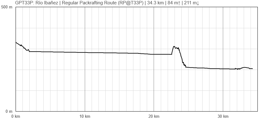
| + | Walk out of Villa Cerro Castillo along a dirt road to the put-in for Río Ibañez located at a rocky beach. At the time of our hike, there was construction going on in this area so don’t be surprised if the put-in changes. The river is wide, slow moving, and at lower flows there are many sandbars hidden just below the surface that will beach even packrafts. After about 20.5 km, packrafters must take out to portage around a Class V+ waterfall at a sandy beach surrounded by steep gravel slopes. The portage is a short cross-country route through farmland which ends at a gate. Just past the gate is Highway X-735. The put-in for the second part of the Río Ibañez float is at a sandy beach. This section of the river to Puerto Ingeniero Ibañez is also very slow moving. Strong winds may make packrafting impractical. | ||
| + | |||
| + | Town: Puerto Ingeniero Ibañez Puerto Ingeniero Ibañez is a small town with a few food options and a small grocery store. The docks for the ferry to Chile Chico across Lago General Carrera is located on the southeast edge of town. | ||
==Season 2016/17== | ==Season 2016/17== | ||
Revisión del 21:39 12 sep 2023
Add a new log entry always on top in the appropriate season sub-chapter and use format:
* Start Date to Finish Date (use Format YYYY-MMM-DD) / Duration in Days / Hiking or Packrafting / Travel Direction (SOBO for Southbound or NOBO Northbound) / Chosen Route and/or Option Name (RR for Regular Route) / Names or Alias
Summary with remarks to route that are considered useful for other hikers and packrafters. Include alerts, suggestions and personal perception of attractiveness and difficulties.
Add a sub-chapter by placing two "=" before and after the new sub-chapter heading ('==Sub-Chapter Heading==').
Contenido
Section Log, Alerts and Suggestions
Season 2025/26
Season 2024/25
Season 2023/24
Season 2022/23
Season 2021/22
Season 2020/21
Season 2019/20
Season 2018/19
Season 2017/18
- Route description by Kara Davis after Season 2017/18:
Walk out of Villa Cerro Castillo along a dirt road to the put-in for Río Ibañez located at a rocky beach. At the time of our hike, there was construction going on in this area so don’t be surprised if the put-in changes. The river is wide, slow moving, and at lower flows there are many sandbars hidden just below the surface that will beach even packrafts. After about 20.5 km, packrafters must take out to portage around a Class V+ waterfall at a sandy beach surrounded by steep gravel slopes. The portage is a short cross-country route through farmland which ends at a gate. Just past the gate is Highway X-735. The put-in for the second part of the Río Ibañez float is at a sandy beach. This section of the river to Puerto Ingeniero Ibañez is also very slow moving. Strong winds may make packrafting impractical.
Town: Puerto Ingeniero Ibañez Puerto Ingeniero Ibañez is a small town with a few food options and a small grocery store. The docks for the ferry to Chile Chico across Lago General Carrera is located on the southeast edge of town.
Season 2016/17
Resupply and Accommodation
Resupply and Accommodation in nearby Towns
Resupply and Accommodation along the Route
Transport to and from Route
Permits, Entry Fees and Right-of-Way Issues
Links to other Resources
Retired Section Article GPT33P - Río Ibañez
Images
[[Archivo: | ]]
| GPT33P: Río Ibañez | Hiking | Packrafting | |||||
| Group | H: Aysen Sur | Total | - | - | 34.3 km | 7 h | |
| Region | Chile: Aysén (XI) | Trails (TL) | - | - | - | - | |
| Start | Villa Cerro Castillo | Minor Roads (MR) | - | - | 2.3 km | 6.6% | |
| Finish | Puerto Ingeniero Ibañez (Puerto) | Primary Roads (PR) | - | - | 2.4 km | 7.0% | |
| Status | Published & Verified | Cross-Country (CC) | - | - | 1.9 km | 5.4% | |
| Traversable | Sep - May | Bush-Bashing (BB) | - | - | - | - | |
| Packraft | Required | Ferry (FY) | - | - | - | - | |
| Connects to | GPT32, GPT33H, GPT34H, GPT34P | Investigation (I) | - | - | - | - | |
| Options | 8 km (Variants Only) | Exploration (EXP) | - | - | - | - | |
| Hiking | Packrafting | Total on Water | 27.8 km | 80.9% | |||
| Attraction | - | 4 (of 5) | River (RI) | 27.8 km | 80.9% | ||
| Difficulty | - | 3 (of 5) | Lake (LK) | - | - | ||
| Direction | None | Only ↓ | Fjord (FJ) | - | - | ||
| Comment | Hiking: Hiking not feasible | ||||||
| Character | Farmland, Settlers, River Packrafting | ||||||
| Challenges | - | ||||||
Elevation Profile of Regular Packrafting Route

