![]()
Diferencia entre revisiones de «GPT17P - Neltume»
(→Comments to Regular Packrafting Route) |
|||
| Línea 26: | Línea 26: | ||
}} | }} | ||
{{Table all GPTs}} | {{Table all GPTs}} | ||
| − | |||
| − | |||
| − | |||
| − | |||
| − | |||
| − | |||
==Recent Alerts and Suggestions== | ==Recent Alerts and Suggestions== | ||
| − | + | ==Season Section Log== | |
| − | + | ==Summary Table== | |
| − | + | ==Satellite Image Map== | |
| − | + | ==Elevation Profile== | |
| − | + | ====Elevation Profile of Regular Packrafting Route==== | |
| − | + | [[File:profile GPT17P.PNG|frame|center|Elevation Profile of Regular Hiking Route (2019)]] | |
| − | + | ||
| − | + | ||
| − | + | ||
| − | + | ||
| − | + | ||
| − | + | ||
| − | + | ||
| − | + | ||
| − | + | ||
| − | + | ||
| − | ==Section | + | |
| − | + | ||
| − | + | ||
| − | + | ||
| − | + | ||
| − | + | ||
| − | + | ||
| − | + | ||
| − | + | ||
| − | + | ||
| − | + | ||
| − | + | ||
| − | + | ||
| − | + | ||
| − | + | ||
| − | + | ||
| − | + | ||
| − | + | ||
| − | + | ||
| − | + | ||
| − | + | ||
| − | + | ||
| − | + | ||
| − | + | ||
| − | + | ||
| − | + | ||
| − | + | ||
| − | + | ||
| − | | | + | |
| − | + | ||
| − | + | ||
| − | + | ||
| − | + | ||
| − | + | ||
| − | + | ||
| − | + | ||
| − | + | ||
| − | + | ||
| − | + | ||
| − | + | ||
| − | + | ||
| − | + | ||
| − | + | ||
| − | + | ||
| − | + | ||
| − | + | ||
| − | + | ||
| − | + | ||
| − | + | ||
| − | + | ||
| − | + | ||
| − | + | ||
| − | + | ||
| − | + | ||
| − | + | ||
| − | + | ||
==Section Planning Status== | ==Section Planning Status== | ||
==Recommended Travel Period== | ==Recommended Travel Period== | ||
| Línea 111: | Línea 39: | ||
==Recommended Travel Direction== | ==Recommended Travel Direction== | ||
==Section Length and Travel Duration== | ==Section Length and Travel Duration== | ||
| + | ==Suitable Section Combinations== | ||
==Section Attractiveness== | ==Section Attractiveness== | ||
==Section Difficulty== | ==Section Difficulty== | ||
==Resupply== | ==Resupply== | ||
| − | ===Resupply | + | ===Resupply Town=== |
| − | ===Resupply | + | ====Shopping: Food==== |
| − | ==Access to Route== | + | ====Shopping: Fuel==== |
| − | ==Permits, Entry Fees | + | ====Shopping: Equipment==== |
| + | ====Services: Restaurants==== | ||
| + | ====Services: Laundry==== | ||
| + | ====Services: ATM and Money Exchange==== | ||
| + | ====Accommodation: Hostals and Hotels==== | ||
| + | ====Accommodation: Cabañas==== | ||
| + | ====Accommodation: Camping==== | ||
| + | ====Transport: Ground Transport==== | ||
| + | ====Transport: Ferries==== | ||
| + | ====Transport: Shipping Services==== | ||
| + | |||
| + | ===Resupply on the Trail=== | ||
| + | ====Location, Names, Available Items and Services==== | ||
| + | |||
| + | ==Access to Route and Return== | ||
| + | ===Access to Start=== | ||
| + | ===Return from Finish=== | ||
| + | ===Escape Options=== | ||
| + | ==Permits, Entry Fees and Right-of-Way Issues== | ||
==Regular Route== | ==Regular Route== | ||
| + | ===Regular Hiking Route=== | ||
===Regular Packrafting Route=== | ===Regular Packrafting Route=== | ||
| − | + | *Route description by Kara Davis after Season 2017/18: | |
| − | + | ||
| − | + | ||
| − | + | ||
| − | + | ||
| − | + | ||
| − | Route description by Kara Davis after Season 2017/18: | + | |
| − | + | ||
The GPT does not go through Carriringue, but if you do decide to go into town the route is easy to rejoin by walking south along the paved road, T-29, to Río Liquiñe. There is an established campsite (5.000 CLP/night) which is part of the Red de Turismo Rural where the paved road crosses the river. This campsite has flush toilets, cold showers, and trash. | The GPT does not go through Carriringue, but if you do decide to go into town the route is easy to rejoin by walking south along the paved road, T-29, to Río Liquiñe. There is an established campsite (5.000 CLP/night) which is part of the Red de Turismo Rural where the paved road crosses the river. This campsite has flush toilets, cold showers, and trash. | ||
| − | |||
The Río Liquiñe is windy and narrow. Pay attention to the several semi-submerged fallen trees that litter the river. The packrafting portion of this section ends with a 4 km paddle along the eastern shore of Lago Neltume. There’s easy access to the road, T-29, the entire time, but camping is improbable due to the abundance of private property. At the end of the lake paddle, there is an established campsite (5.000 CLP/night). This site has flush toilets and trash. | The Río Liquiñe is windy and narrow. Pay attention to the several semi-submerged fallen trees that litter the river. The packrafting portion of this section ends with a 4 km paddle along the eastern shore of Lago Neltume. There’s easy access to the road, T-29, the entire time, but camping is improbable due to the abundance of private property. At the end of the lake paddle, there is an established campsite (5.000 CLP/night). This site has flush toilets and trash. | ||
| − | |||
| − | |||
Alternate Route: | Alternate Route: | ||
| − | |||
At this point, the recommended packrafting route turns off T-29 onto a gravel road. DO NOT TAKE THIS ROUTE. It eventually leads to a river that is now impassible due to a destroyed bridge. An alternative is to continue along T-29 until reaching the highway, 203-CH. Follow this highway through Neltume all the way to Puerto Fuy. Although the recommended packrafting route turns off of the highway after Neltume, on the ground it was unclear where this turnoff was. We decided to road walk all the way to Puerto Fuy. | At this point, the recommended packrafting route turns off T-29 onto a gravel road. DO NOT TAKE THIS ROUTE. It eventually leads to a river that is now impassible due to a destroyed bridge. An alternative is to continue along T-29 until reaching the highway, 203-CH. Follow this highway through Neltume all the way to Puerto Fuy. Although the recommended packrafting route turns off of the highway after Neltume, on the ground it was unclear where this turnoff was. We decided to road walk all the way to Puerto Fuy. | ||
| − | |||
| − | |||
Comment by Jan Dudeck: Last season and this season 3 hikers/couples attempted to follow this route (RP-MR-V@17P-25.1). Two turned back, one made it over the river mentioned by Kara above. So the safest option is currently not take regular route (track RP-MR-V@17P-25.1) but stay on the main road taking Variant “H” (track OP-PR-V@17P-H-#). | Comment by Jan Dudeck: Last season and this season 3 hikers/couples attempted to follow this route (RP-MR-V@17P-25.1). Two turned back, one made it over the river mentioned by Kara above. So the safest option is currently not take regular route (track RP-MR-V@17P-25.1) but stay on the main road taking Variant “H” (track OP-PR-V@17P-H-#). | ||
| − | |||
| − | |||
Town: Neltume/Puerto Fuy to Panguipulli | Town: Neltume/Puerto Fuy to Panguipulli | ||
| − | |||
Neltume has options for lodging, a few restaurants, and a bus to Panguipulli—the closest large town for resupply. Ask a local for directions to the bus stop and about arrival times. | Neltume has options for lodging, a few restaurants, and a bus to Panguipulli—the closest large town for resupply. Ask a local for directions to the bus stop and about arrival times. | ||
| − | |||
At Puerto Fuy, there were several signs advertising lodging. However, it would be difficult to resupply here. | At Puerto Fuy, there were several signs advertising lodging. However, it would be difficult to resupply here. | ||
| − | |||
| − | |||
Comment by Jan Dudeck: I recall about half a dozen mini shops in Puerto Fuy that are sometimes hidden in the side roads. But its a best practice to resupply in the first bigger shop you find on the route (i.e. Neltume) and try in the next village to purchase what you did not get in the first place (i.e. Puerto Fuy). | Comment by Jan Dudeck: I recall about half a dozen mini shops in Puerto Fuy that are sometimes hidden in the side roads. But its a best practice to resupply in the first bigger shop you find on the route (i.e. Neltume) and try in the next village to purchase what you did not get in the first place (i.e. Puerto Fuy). | ||
==Optional Routes== | ==Optional Routes== | ||
| − | == | + | ==Investigations and Explorations== |
| + | ==Links to other Resources== | ||
| + | ==Alerts and Logs of Past Seasons== | ||
| + | |||
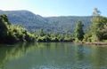
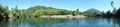
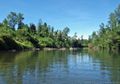
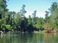
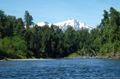
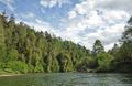
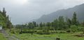
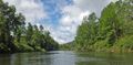
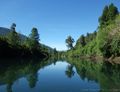
==Images== | ==Images== | ||
<gallery> | <gallery> | ||
| Línea 159: | Línea 91: | ||
File:GPT_11_Neltume_119228009.jpg| | File:GPT_11_Neltume_119228009.jpg| | ||
File:GPT_11_Neltume_119228010.jpg| | File:GPT_11_Neltume_119228010.jpg| | ||
| + | File:GPT_11_Neltume_109269685.jpg|thumb| | ||
| + | File:GPT_11_Neltume_109269706.jpg|thumb| | ||
| + | File:GPT_11_Neltume_109269743.jpg|thumb| | ||
| + | File:GPT_11_Neltume_119227998.jpg|thumb| | ||
</gallery> | </gallery> | ||
| − | |||
| − | |||
| − | |||
| − | |||
| − | |||
| − | |||
| − | |||
| − | |||
| − | |||
| − | |||
| − | |||
| − | |||
| − | |||
| − | |||
| − | |||
| − | |||
| − | |||
| − | |||
| − | |||
| − | |||
| − | |||
| − | |||
| − | |||
| − | |||
| − | |||
| − | |||
| − | |||
| − | |||
| − | |||
| − | |||
| − | |||
| − | |||
| − | |||
| − | |||
| − | |||
| − | |||
| − | |||
| − | |||
| − | |||
| − | |||
| − | |||
| − | |||
| − | |||
| − | |||
Revisión del 17:41 26 oct 2019


| All GPT sections (click to show) |
|---|
|
GPT Section Articles
|
Recent Alerts and Suggestions
Season Section Log
Summary Table
Satellite Image Map
Elevation Profile
Elevation Profile of Regular Packrafting Route

Section Planning Status
Recommended Travel Period
Benefits of Hiking and Packrafting
Recommended Travel Direction
Section Length and Travel Duration
Suitable Section Combinations
Section Attractiveness
Section Difficulty
Resupply
Resupply Town
Shopping: Food
Shopping: Fuel
Shopping: Equipment
Services: Restaurants
Services: Laundry
Services: ATM and Money Exchange
Accommodation: Hostals and Hotels
Accommodation: Cabañas
Accommodation: Camping
Transport: Ground Transport
Transport: Ferries
Transport: Shipping Services
Resupply on the Trail
Location, Names, Available Items and Services
Access to Route and Return
Access to Start
Return from Finish
Escape Options
Permits, Entry Fees and Right-of-Way Issues
Regular Route
Regular Hiking Route
Regular Packrafting Route
- Route description by Kara Davis after Season 2017/18:
The GPT does not go through Carriringue, but if you do decide to go into town the route is easy to rejoin by walking south along the paved road, T-29, to Río Liquiñe. There is an established campsite (5.000 CLP/night) which is part of the Red de Turismo Rural where the paved road crosses the river. This campsite has flush toilets, cold showers, and trash. The Río Liquiñe is windy and narrow. Pay attention to the several semi-submerged fallen trees that litter the river. The packrafting portion of this section ends with a 4 km paddle along the eastern shore of Lago Neltume. There’s easy access to the road, T-29, the entire time, but camping is improbable due to the abundance of private property. At the end of the lake paddle, there is an established campsite (5.000 CLP/night). This site has flush toilets and trash. Alternate Route: At this point, the recommended packrafting route turns off T-29 onto a gravel road. DO NOT TAKE THIS ROUTE. It eventually leads to a river that is now impassible due to a destroyed bridge. An alternative is to continue along T-29 until reaching the highway, 203-CH. Follow this highway through Neltume all the way to Puerto Fuy. Although the recommended packrafting route turns off of the highway after Neltume, on the ground it was unclear where this turnoff was. We decided to road walk all the way to Puerto Fuy. Comment by Jan Dudeck: Last season and this season 3 hikers/couples attempted to follow this route (RP-MR-V@17P-25.1). Two turned back, one made it over the river mentioned by Kara above. So the safest option is currently not take regular route (track RP-MR-V@17P-25.1) but stay on the main road taking Variant “H” (track OP-PR-V@17P-H-#). Town: Neltume/Puerto Fuy to Panguipulli Neltume has options for lodging, a few restaurants, and a bus to Panguipulli—the closest large town for resupply. Ask a local for directions to the bus stop and about arrival times. At Puerto Fuy, there were several signs advertising lodging. However, it would be difficult to resupply here. Comment by Jan Dudeck: I recall about half a dozen mini shops in Puerto Fuy that are sometimes hidden in the side roads. But its a best practice to resupply in the first bigger shop you find on the route (i.e. Neltume) and try in the next village to purchase what you did not get in the first place (i.e. Puerto Fuy).
Optional Routes
Investigations and Explorations
Links to other Resources
Alerts and Logs of Past Seasons
Images
thumb|
thumb|
thumb|
thumb|


