![]()
Diferencia entre revisiones de «ENG:Caleu-Ocoa»
(→Tiempo esperado) |
(→Variantes) |
||
| Línea 54: | Línea 54: | ||
En este punto, comienza un breve tramo abrupto para los ciclistas (sin problema para los caminantes) marcado como "Tramo escarpado" en el mapa (si se siguiera avanzando por el filo, se recorrería la ruta [[Caleu - Olmué]]). Se deben bajar unos pocos metro hasta el paso que separa los dos valles, donde hay registros de campamentos. A la izquierda se ve un sendero que conduce al valle de Olmué, pero se debe tomar el sendero poco marcado de la derecha. Éste zigzaguea por la ladera, entre los arbustos y espinos, bajando bruscamente desde 1404 hasta 1135, punto en que empalma con el sendero "La Mina" del Parque Nacional Palmas de Ocoa y donde la ruta se vuelve "civilizada" para los ciclistas. Pocos metros más adelante, se debe cruzar un puente de madera en muy mal estado, y luego continuar un agradable descenso. Poco más adelante, aparecen las primeras palmas. Tras un tramo largo por la misma ladera, se llegará a un cartel que marca "Cascada: 0,5 km" a mano derecha, marcado como "bifurcación cascada 2" porque este sendero es más común recorrerlo en sentido contrario. Es posible visitar la cascada y volver (vale la pena). Luego el sendero cruza un estero con agua todo el año y continúa bajando hasta otra bifurcación a la misma cascada, marcado como "bifurcación cascada 1". Luego se llega al sector de Casino, con muchas palmas, y luego al estacionamiento superior ("El Peral") para finalmente llegar a la entrada al Parque Nacional, donde hay guardaparques. | En este punto, comienza un breve tramo abrupto para los ciclistas (sin problema para los caminantes) marcado como "Tramo escarpado" en el mapa (si se siguiera avanzando por el filo, se recorrería la ruta [[Caleu - Olmué]]). Se deben bajar unos pocos metro hasta el paso que separa los dos valles, donde hay registros de campamentos. A la izquierda se ve un sendero que conduce al valle de Olmué, pero se debe tomar el sendero poco marcado de la derecha. Éste zigzaguea por la ladera, entre los arbustos y espinos, bajando bruscamente desde 1404 hasta 1135, punto en que empalma con el sendero "La Mina" del Parque Nacional Palmas de Ocoa y donde la ruta se vuelve "civilizada" para los ciclistas. Pocos metros más adelante, se debe cruzar un puente de madera en muy mal estado, y luego continuar un agradable descenso. Poco más adelante, aparecen las primeras palmas. Tras un tramo largo por la misma ladera, se llegará a un cartel que marca "Cascada: 0,5 km" a mano derecha, marcado como "bifurcación cascada 2" porque este sendero es más común recorrerlo en sentido contrario. Es posible visitar la cascada y volver (vale la pena). Luego el sendero cruza un estero con agua todo el año y continúa bajando hasta otra bifurcación a la misma cascada, marcado como "bifurcación cascada 1". Luego se llega al sector de Casino, con muchas palmas, y luego al estacionamiento superior ("El Peral") para finalmente llegar a la entrada al Parque Nacional, donde hay guardaparques. | ||
| − | === | + | === Variants === |
| − | * | + | * If the route is made in the direction described (Caleu - Ocoa) it is perfectly possible (especially on a bicycle but also on foot) to climb to the summit of El Roble (see [[Cerro el Roble (vehicular route)]], then go down and take the fork to Olmué. |
| − | * | + | * When the steep section ends and the "La Mina" trail is reached, you can turn right and, only 200 meters further on, you reach the quartz mine and a mysterious bus abandoned in the middle of the ravine (? ). |
| − | * | + | * From "cascade bifurcation 2", you can take the detour to the waterfall and then, instead of going back to the route you came from, continue on that path until you join at "bifurcation waterfall 1". |
| + | |||
=== Expected time === | === Expected time === | ||
* '''Trekking''': At a normal pace, this trekking should take about 4 to 5 hours between the access gate to Oak and CONAF de Ocoa. | * '''Trekking''': At a normal pace, this trekking should take about 4 to 5 hours between the access gate to Oak and CONAF de Ocoa. | ||
Revisión del 19:18 6 jun 2019

| |


|
|
| |||||||||||||||||||||||||||||||||||||||||||||||||||||||||||||||||||||||||||


Appropriate time
All year. Ideal at the end of May and beginning of June, when the oaks are bright red.
Access
By car

From Santiago, you must take the Pan-American highway (route 5) in the north direction. The detour to Rungue is at kilometer 54. You must take that exit and enter the town. Where the street ends, we must turn left and, a few meters further on, turn right (the street ends anyway) to cross an estuary. Immediately after crossing the estuary, you should turn left, and begin to skirt the estuary along a gravel road in good condition. The Rungue reservoir will then be bordered. After 3.9 kilometers from the Pan-American highway, there is a detour to the right ("A Caleu") which must be taken. This road, also gravel in good condition, goes through the valley and ascends progressively. Approximately on the 11th kilometer from the turnoff (14.9 from the Pan-American Highway) Caleu has been reached and a fork arises: you must take the left, which continues up the hill. 970 meters above, just before the passage to the valley of Olmué, the path to the oak tree appears on the right.
In public transport and hitchhiking
From the La Paz bus terminal, located on Avenida La Paz and Dávila Baeza street, daily buses depart for Til Til, from 6 AM and every 15 minutes. At 16.00, a bus leaves for Caleu. Passage value $ 1,600. It is quite a busy road, so the possibilities of hitchhiking are rather high.


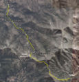
Description of the route

The route starts at the access gate to El Roble, at 1242 masl (although it is possible to continue driving 4.1 kilometers more, up to 1680 masl). The route is very clear until the fork to Ocoa, because it is a vehicular road built for the construction and maintenance of the antennas of the summit. A normal weekend (especially after snowfall), there should be some cars on the road. It should start to walk towards the west. The road climbs without stopping until the fork. The first section is by the edge of this southern foothill of the hill. Then it reaches the edge that divides the valleys of Caleu and Olmué. To the west, there are beautiful views of the palmar of Ocoa and La Campana. Shortly after this first view of the Olmué valley, a pedestrian fork appears for the path that leads to Ocoa (1680 masl and highest point of the route). Turn left, heading west. For the summit of the Oak tree, you must continue along the main vehicular road, along the route described in Cerro el Roble (vehicular route). The route is wide and pleasant, in the shadow of the northernmost oaks of the Southern Hemisphere, and it enters with a gentle slope along the southern slope of the edge that separates the two valleys. After 2.3 kilometers, the footprint is passed to the northern slope of this edge, with more sun exposure, and the vegetation will flatten suddenly, disappearing oaks, but getting in return a beautiful view of the palmar of Ocoa at our feet. One more kilometer should be traveled along this wide route until it empties into an old quartz mine (on the southern slope).
En este punto, comienza un breve tramo abrupto para los ciclistas (sin problema para los caminantes) marcado como "Tramo escarpado" en el mapa (si se siguiera avanzando por el filo, se recorrería la ruta Caleu - Olmué). Se deben bajar unos pocos metro hasta el paso que separa los dos valles, donde hay registros de campamentos. A la izquierda se ve un sendero que conduce al valle de Olmué, pero se debe tomar el sendero poco marcado de la derecha. Éste zigzaguea por la ladera, entre los arbustos y espinos, bajando bruscamente desde 1404 hasta 1135, punto en que empalma con el sendero "La Mina" del Parque Nacional Palmas de Ocoa y donde la ruta se vuelve "civilizada" para los ciclistas. Pocos metros más adelante, se debe cruzar un puente de madera en muy mal estado, y luego continuar un agradable descenso. Poco más adelante, aparecen las primeras palmas. Tras un tramo largo por la misma ladera, se llegará a un cartel que marca "Cascada: 0,5 km" a mano derecha, marcado como "bifurcación cascada 2" porque este sendero es más común recorrerlo en sentido contrario. Es posible visitar la cascada y volver (vale la pena). Luego el sendero cruza un estero con agua todo el año y continúa bajando hasta otra bifurcación a la misma cascada, marcado como "bifurcación cascada 1". Luego se llega al sector de Casino, con muchas palmas, y luego al estacionamiento superior ("El Peral") para finalmente llegar a la entrada al Parque Nacional, donde hay guardaparques.
Variants
- If the route is made in the direction described (Caleu - Ocoa) it is perfectly possible (especially on a bicycle but also on foot) to climb to the summit of El Roble (see Cerro el Roble (vehicular route), then go down and take the fork to Olmué.
- When the steep section ends and the "La Mina" trail is reached, you can turn right and, only 200 meters further on, you reach the quartz mine and a mysterious bus abandoned in the middle of the ravine (? ).
- From "cascade bifurcation 2", you can take the detour to the waterfall and then, instead of going back to the route you came from, continue on that path until you join at "bifurcation waterfall 1".
Expected time
- Trekking: At a normal pace, this trekking should take about 4 to 5 hours between the access gate to Oak and CONAF de Ocoa.
- Mountain Bike: About two and a half hours to three hours.
It is possible to shorten both times in about 40 minutes if you drive up to the fork to Ocoa.
Permits / Rates
- You must cancel $ 4000 (US$ 6.5 as of May 2018) per adult to enter (free children). The entrance is administered by the Association of Communes Chapel of Caleu, and is open weekends and holidays from 9 a.m. to 1:00 p.m. In case of going one business day and wanting to cross the gate by car, you should call the cell phone +56984759457 or +56962382245.
Recommendations
- Checklist: Aunque sepas perfectamente lo que debes llevar, es preferible chequearlo al empacar. Esta ruta ha sido clasificada como Type 1 equipment checklist: low altitude route, without camping, snow or cold.
- It is recommended to bring a headlight to go through the first meters of the quartz mine that gives its name to the "La Mina" trail (the one in the Ocoa valley, not the one on the edge)
- The section from the "waterfall bifurcation 2" is described in more detail in P.N. La Campana, Ocoa
- It is not recommended to make a round trip by bicycle: there is a quite heavy section of 200m of unevenness where you have to carry the bike on your shoulder.
Weather forecast
- Meteochile Region of Valparaíso
- Accuweather Valparaíso
- Accuweather Viña del Mar
- Meteochile Metropolitan Region
- Accuweather Santiago
- Accuweather Puente Alto
Horseback riding in La Campana National Park
To hire horses in the La Campana National Park, it is possible to contact Marco at +56967348561 and +56332271996. Marco Cobra $ 4,000 / hour per horse $ 4000 (US$ 6.5 as of May 2018). In two to three hours you can walk quite well the main forests of palms, and in three to five hours you can reach the waterfall and other points of interest of the park.
Hire guided tours and excursions
- Denomades.com: Tours y trekkings regulares y privados en el Cajón del Maipo y otros destinos. Contacto directo con los mejores operadores locales.
- Contacto: reservas@denomades.com
- Teléfono: +56 229551857
- Facebook: Denomades.com
Photo Gallery
Mapa de la ruta Caleu - Ocoa

Revisa la lista completa de 554 rutas de trekking y las 344 rutas de montaña en Chile
|